Bridgetown
From CruisersWiki
m (Text replace - "{|id="mp-right" width="100%" cellpadding="2" cellspacing="1" style="vertical-align:top; background:#f5faff; border:1px solid #a3b0bf;" ! <h2 id="mp-itn-h2" style="margin:0; background:#cedff2; font-size:120%; font-weight:bold; border:1px s) |
m (Text replace - "==References & Publications==" to "==References==") |
||
| (31 intermediate revisions not shown) | |||
| Line 1: | Line 1: | ||
| - | + | {{IsPartOf|North Atlantic|Caribbean|Lesser Antilles|Barbados}} | |
| - | + | {{TOC block}} | |
| - | + | ||
| - | === | + | {{Infobox | lat=13.09933 | lon=-59.63033 |
| - | + | | portofentry= y | |
| + | | zoom= 14 | ||
| + | | chartlet = y | ||
| + | | image= Barbados_BridgetownS.jpg | ||
| + | | imagetext= Satellite Image of Bridgetown | ||
| + | }} | ||
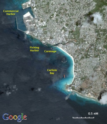
| + | [http://en.wikipedia.org/wiki/Bridgetown Bridgetown] is the main port and the capital and largest city of [[Barbados]]. It has a populations of 96,578 (2006). | ||
| - | + | ==Charts== | |
| + | ''See [[Barbados#Charts|Barbados]]''. | ||
| - | == | + | ==Weather== |
| - | See [[Barbados# | + | ''See [[Barbados#Weather|Barbados]]''. |
| - | == | + | ==Passages== |
| - | + | * [[Trans-Atlantic,_Europe_to_Caribbean|Trans-Atlantic, Europe to Caribbean Passage]] | |
| + | * [[Trans-Atlantic, Caribbean to Europe Passage]] | ||
| - | + | ==Communication== | |
| + | {{Green|Add here VHF channel for coastguard, harbor masters. etc.}} | ||
| + | * | ||
| + | * | ||
| - | + | ''Also see [[World MM Nets|World Cruiser's Nets]]'' | |
| - | + | ||
| - | == | + | ==Navigation== |
| - | + | Approaching [[#Carlisle_Bay|Carlisle Bay]], the large bay south of the main harbor presents no problems. | |
| - | == | + | ==Entrance== |
| - | + | [[Bridgetown]] is a port of entry to [[Barbados]]. You must clear in the [[#Commercial_Harbor|Commercial Harbor]]. | |
| - | + | ||
| - | + | ||
| - | + | ''For entering/exiting procedures see [[Barbados#Customs_and_Immigration|Barbados]]''. | |
| - | + | ==Berthing== | |
| - | | | + | ===Ports=== |
| + | The main harbor in Bridgetown is the [[#Commercial_Harbor|Commercial Harbor]] where you will have to for clearing customs. The other harbor is the [[#Fishing_Harbor|Fishing Harbor]] which is the only place where there is fuel. It is too small, however for a yacht. Yachts in Bridgetown go either to the protected [[#Careenage|Careenage]] or anchor off in [[#Carlisle_Bay|Carlisle Bay]]. | ||
| - | + | {{Poi | lat= 13.10634 | lon= -59.63127 | type= harbour | name= Commercial Harbor | zoom= 16 | |
| - | { | + | | image= Barbados_ComHarbor.jpg |
| - | + | | imagetext= The Commercial Harbor in Bridgetown | |
| - | The | + | | imagewidth= |
| + | | portofentry= y | ||
| + | | text= You have to come here when clearing into Barbados. Before you do so, call ''Bridgetown Harbor Control'' on the VHF channel 16. They will direct in the harbor. The harbor officials are friendly, one of them even speaks Greek! Clearing-in procedures are friendly. You can talk the officials into allowing to clear-out without bringing the yacht into the harbor. Clearing-out procedures are longer. | ||
| - | + | {{Warning}}The harbor has a very bad swell, the quays are very high, and the bollards far apart. This is a harbor for cruise ships and not for yachts. | |
| + | {{hold vertical}}}} | ||
| - | + | {{hold vertical}} | |
| - | + | ||
| + | {{Poi |lat= 13.09604| lon= -59.61595 | type= harbour | name= Careenage| zoom= 17 | ||
| + | | image= Barbados_Careenage.jpg | ||
| + | | imagetext= The Careenage in Bridgetown | ||
| + | | imagewidth= | ||
| + | | text= The Careenage is a river inlet and the inner harbor of [http://www.barbados.org/btown.htm Bridgetown] where all the large recreational fishing boats are berthed. It is maybe the most secure place for a yacht but it is noisy and crowded. You may not find a berth. I am not sure how much a berth costs. | ||
| - | + | {{Warning}}Dinghy theft is endemic here. Lock your dinghy whenever you leave it unattended. }} | |
| - | { | + | |
| - | + | ||
| - | + | ||
| - | | | + | {{hold vertical}} |
| - | + | ||
| + | {{Poi | lat= 13.09574| lon= -59.61984 | type= harbour | name= Fishing Harbor | zoom= 18 | ||
| + | | image= Barbados_FishHarbor.jpg | ||
| + | | imagetext= The Fishing Harbor in Bridgetown | ||
| + | | imagewidth= | ||
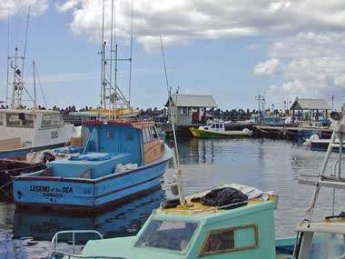
| + | | text= This is a small, and dirty, harbor used by commercial fishing boats. It is too small for a yacht. It has, however, two fuel stations, an ''Esso'' and a ''Texaco''. You can easily come here with the dingy and fill your jerry-cans. Also, this is good place to come and then go to the Customs, a 10 minute walk, for clearing-out procedures.}} | ||
===Marinas & Yacht Clubs=== | ===Marinas & Yacht Clubs=== | ||
None. | None. | ||
| + | {{hold vertical}} | ||
| - | + | ==Anchorages== | |
| - | + | {{Poi | lat= 13.08808| lon= -59.61292 | type= anchorage | name= Carlisle Bay | zoom= 15 | |
| - | + | | image= Barbados_Carlisle.jpg | |
| - | + | | imagetext= Carlisle Bay | |
| - | Carlisle Bay is a large bay where most of the visiting yachts anchor. When we were there it was comfortable but one can see that with a strong swell it may not be so. It is, however, quiet and lovely. Anchor anywhere in 5 m depth over sand. Good holding. | + | | imagewidth= |
| + | | text= Carlisle Bay is a large bay where most of the visiting yachts anchor. When we were there it was comfortable but one can see that with a strong swell it may not be so. It is, however, quiet and lovely. Anchor anywhere in 5 m depth over sand. Good holding. | ||
In the middle of the bay is the Boatyard, a bar/restaurant. They maintain a private pier where you can tie the dinghy. They want $20 BBD ($1 USD = $2 BBD) per day for the use of their pier and their other facilities i.e. cold shower but they do give you a number of chips which you can use for drinks or food (not particularly very good). | In the middle of the bay is the Boatyard, a bar/restaurant. They maintain a private pier where you can tie the dinghy. They want $20 BBD ($1 USD = $2 BBD) per day for the use of their pier and their other facilities i.e. cold shower but they do give you a number of chips which you can use for drinks or food (not particularly very good). | ||
| - | Another option is to drive the dingy about 1 M to Careenage where you can tie it and be right in the middle of Bridgetown. | + | Another option is to drive the dingy about 1 M to Careenage where you can tie it and be right in the middle of Bridgetown.}} |
| + | ==Amenities== | ||
| + | ''See [[Barbados#Amenities|Barbados]]''. | ||
| - | == | + | ==Provisioning== |
| - | + | ''See [[Barbados#Provisioning |Barbados]]''. | |
| - | == | + | ==Eating out== |
| - | [ | + | ''See [[Barbados#Eating out |Barbados]]''. |
| - | + | ==Transportation== | |
| - | + | ''See [[Barbados#Transportation |Barbados]]''. | |
| - | + | ||
| - | + | ||
| - | == | + | ==Tourism== |
| - | + | ''See [[Barbados#Tourism |Barbados]]''. | |
| - | + | ||
| - | == | + | ==Friends== |
| - | + | ||
| - | + | ||
| - | + | ||
| - | + | ||
| - | + | ||
| - | + | ||
| - | + | ||
| - | + | ||
| - | + | ||
| - | + | ||
| - | + | ||
| - | + | ||
| - | + | ||
| - | + | ||
| - | + | ||
| - | + | ||
| - | + | ||
| - | + | ||
Contact details of "Cruiser's Friends" that can be contacted for local information or assistance. | Contact details of "Cruiser's Friends" that can be contacted for local information or assistance. | ||
| - | == | + | ==Forums== |
| - | List links to discussion threads on [[Cruising Forums|partnering forums]]. (see link for requirements) | + | List links to discussion threads on [[Cruising Forums|partnering forums]]. (''see link for requirements'') |
| - | + | ||
* | * | ||
* | * | ||
| - | == | + | ==Links== |
| + | * {{wikipedia}} | ||
* [http://www.barbados.org/btown.htm Bridgetown] | * [http://www.barbados.org/btown.htm Bridgetown] | ||
| + | * {{Wikivoyage}} | ||
* | * | ||
| + | |||
| + | ==References== | ||
| + | ''See [[Barbados#References_&_Publications|Barbados]]''. | ||
| + | |||
| + | {{Comments}} | ||
* | * | ||
| - | + | {{Verified by}} | |
| - | + | ||
| - | + | ||
| - | + | ||
| - | + | ||
| - | + | ||
* February 2005 --[[User:Istioploos|Istioploos]] [[Image:Greece_Icon.png]] | * February 2005 --[[User:Istioploos|Istioploos]] [[Image:Greece_Icon.png]] | ||
* | * | ||
| - | {{ | + | {{Page useable}} |
| + | |||
| + | {{Contributors|[[User:Lighthouse|Lighthouse]], [[User:Istioploos|Istioploos]]}} | ||
| - | + | [[Category:Ports - Caribbean]] [[Category:Anchorages - Caribbean]] | |
| - | + | ||
| - | + | ||
| - | + | ||
| - | + | ||
| - | + | ||
| - | + | ||
| - | + | ||
| - | + | ||
| - | + | ||
| - | + | ||
| - | + | ||
| - | + | ||
| - | + | ||
| - | + | ||
| - | + | ||
Latest revision as of 11:43, 15 August 2018
| Bridgetown Port of Entry
| |
| | |
Bridgetown is the main port and the capital and largest city of Barbados. It has a populations of 96,578 (2006).
Charts
See Barbados.
Weather
See Barbados.
Passages
Communication
Add here VHF channel for coastguard, harbor masters. etc.
Also see World Cruiser's Nets
Approaching Carlisle Bay, the large bay south of the main harbor presents no problems.
Entrance
Bridgetown is a port of entry to Barbados. You must clear in the Commercial Harbor.
For entering/exiting procedures see Barbados.
Berthing
Ports
The main harbor in Bridgetown is the Commercial Harbor where you will have to for clearing customs. The other harbor is the Fishing Harbor which is the only place where there is fuel. It is too small, however for a yacht. Yachts in Bridgetown go either to the protected Careenage or anchor off in Carlisle Bay.
Commercial Harbor
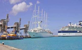
You have to come here when clearing into Barbados. Before you do so, call Bridgetown Harbor Control on the VHF channel 16. They will direct in the harbor. The harbor officials are friendly, one of them even speaks Greek! Clearing-in procedures are friendly. You can talk the officials into allowing to clear-out without bringing the yacht into the harbor. Clearing-out procedures are longer.
Warning: The harbor has a very bad swell, the quays are very high, and the bollards far apart. This is a harbor for cruise ships and not for yachts.
Careenage
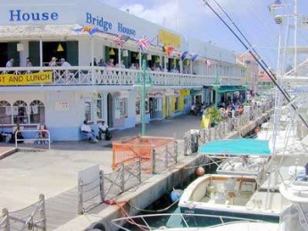
The Careenage is a river inlet and the inner harbor of Bridgetown where all the large recreational fishing boats are berthed. It is maybe the most secure place for a yacht but it is noisy and crowded. You may not find a berth. I am not sure how much a berth costs.
Warning: Dinghy theft is endemic here. Lock your dinghy whenever you leave it unattended.Fishing Harbor
Marinas & Yacht Clubs
None.
Anchorages
Carlisle Bay
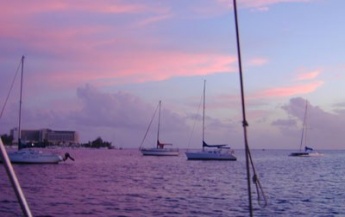
Carlisle Bay is a large bay where most of the visiting yachts anchor. When we were there it was comfortable but one can see that with a strong swell it may not be so. It is, however, quiet and lovely. Anchor anywhere in 5 m depth over sand. Good holding.
In the middle of the bay is the Boatyard, a bar/restaurant. They maintain a private pier where you can tie the dinghy. They want $20 BBD ($1 USD = $2 BBD) per day for the use of their pier and their other facilities i.e. cold shower but they do give you a number of chips which you can use for drinks or food (not particularly very good).
Another option is to drive the dingy about 1 M to Careenage where you can tie it and be right in the middle of Bridgetown.Amenities
See Barbados.
Provisioning
See Barbados.
Eating out
See Barbados.
Transportation
See Barbados.
Tourism
See Barbados.
Friends
Contact details of "Cruiser's Friends" that can be contacted for local information or assistance.
Forums
List links to discussion threads on partnering forums. (see link for requirements)
Links
- Bridgetown at the Wikipedia
- Bridgetown
- Bridgetown at the Wikivoyage
References
See Barbados.
Comments
We welcome users' contributions to the Wiki. Please click on Comments to view other users' comments, add your own personal experiences or recommend any changes to this page following your visit.
Verified by
Date of member's last visit to Bridgetown and this page's details validated:
- February 2005 --Istioploos

| This is a usable page of the cruising guide. However, please contribute if you can to help it grow further. Click on Comments to add your personal notes on this page or to discuss its contents. Alternatively, if you feel confident to edit the page, click on the edit tab at the top and enter your changes directly. |
| |
|---|
|
Names: Lighthouse, Istioploos |
