Ionian Coast, Turkey
From CruisersWiki
(Difference between revisions)
Istioploos (Talk | contribs) (→Ports, Anchorages, and Islands: Links) |
Istioploos (Talk | contribs) (Interactive Map) |
||
| Line 2: | Line 2: | ||
An online cruising guide for yachts sailing around the Ionian Coast of [[Turkey]]. | An online cruising guide for yachts sailing around the Ionian Coast of [[Turkey]]. | ||
| - | + | <imagemap> | |
| - | | | + | Image:TurkeyIonian.jpg|center|frame|The Ionian Coast of Turkey - <em>For details click on a name or an area</em> |
| - | | | + | poly 209 177 216 193 217 235 175 235 178 211 199 197 [[Sigacik_Region#Ala.C3.A7ati_Bay_or_Agriler_Liman|Agriler Liman or Alaçati Bay]] |
| - | | | + | rect 225 177 252 220 [[Sigacik_Region#Mersin_K.C3.B6rfezi|Mersin Körfesi]] |
| - | | | + | poly 251 221 266 215 263 275 208 276 208 249 [[Sigacik_Region#Sarpdere_Liman.C4.B1|Sarpede Liman]] |
| - | + | poly 271 257 281 237 305 291 306 312 249 312 249 285 [[Sigacik_Region#K.C4.B1rkdilim_Liman|Kirdilim Liman]] | |
| + | poly 263 197 319 197 314 253 299 257 266 217 [[Sigacik_Region#Gökkovar_Liman|Gökkovar Liman]] | ||
| + | rect 355 190 411 223 [[Sigacik_Region#Si.C4.9Facik|Siğacik]] | ||
| + | rect 339 229 391 262 [[Sigacik_Region#Teos_Liman|Teos Liman]] | ||
| + | rect 371 289 423 335 [[Sigacik_Region#K.C3.B6rmen_Adasi_or_Bolme_Adasi|Körmen or Bolme Adasi]] | ||
| + | rect 480 355 570 405 [[Kusadasi|Kuşadasi]] | ||
| + | rect 380 478 460 535 [[Kusadasi#Port_Saint_Paul_.26_Saint_Nikolo|Port Saint Paul & Saint Nikolo]] | ||
| + | rect 477 632 537 657 [[Gulluk_Korfesi#.C3.87ukurcuk|Çukurcuk]] | ||
| + | poly 539 603 573 603 574 653 567 653 542 625 [[Didim Marina]] | ||
| + | poly 577 650 572 631 576 604 561 596 562 584 607 584 603 603 586 633 587 646 [[Gulluk_Korfesi#Altinkum|Altinkum]] | ||
| + | rect 618 624 653 657 [[Gulluk_Korfesi#Kazikli_Liman|Kazikli Liman]] | ||
| + | poly 588 683 625 683 666 690 656 696 618 704 593 705 [[Gulluk_Korfesi#Shiero_Bay|Shiero Bay]] | ||
| + | poly 662 669 667 649 700 649 700 670 687 686 677 686 [[Gulluk_Korfesi#Asin_Liman|Asin Liman]] | ||
| + | rect 657 701 700 721 [[Gulluk]] | ||
| + | poly 610 722 637 722 656 736 657 749 639 752 610 746 [[Gulluk_Korfesi#Salih_Adasi|Salih Adasi]] | ||
| + | poly 581 753 597 739 609 747 610 777 581 777 [[Gulluk_Korfesi#T.C3.BCrk_B.C3.BCk.C3.BC|Türk Bükü]] | ||
| + | </imagemap> | ||
| + | |||
| + | {{TOCleft}} | ||
The Ionian Coast is rather popular by yachts in [[Turkey]]. It takes its name from the [http://en.wikipedia.org/wiki/Ionia Ionia] an ancient region of central coastal Anatolia in present-day [[Turkey]]. It extends south of the [[Cesme|Çesme]] to [[Kusadasi|Kuşadasi]], [[Altinkum]] and the Gulf of [[Gulluk]]. | The Ionian Coast is rather popular by yachts in [[Turkey]]. It takes its name from the [http://en.wikipedia.org/wiki/Ionia Ionia] an ancient region of central coastal Anatolia in present-day [[Turkey]]. It extends south of the [[Cesme|Çesme]] to [[Kusadasi|Kuşadasi]], [[Altinkum]] and the Gulf of [[Gulluk]]. | ||
| Line 109: | Line 127: | ||
| - | {{ | + | {{Guide2}} |
Revision as of 16:57, 17 February 2015
Ionian Coast Cruising Guide
An online cruising guide for yachts sailing around the Ionian Coast of Turkey.
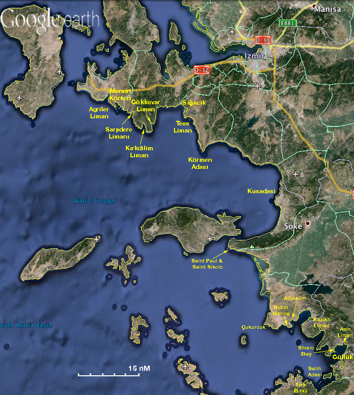

The Ionian Coast of Turkey - For details click on a name or an area
|
The Ionian Coast is rather popular by yachts in Turkey. It takes its name from the Ionia an ancient region of central coastal Anatolia in present-day Turkey. It extends south of the Çesme to Kuşadasi, Altinkum and the Gulf of Gulluk.
- BA
- 1546 Samos Strait to Güllük Körfezi
- 1645 Nisos Chios and Izmir Körfezi
- Imray-Tetra
- G32 Eastern Sporades, Dodecanese & the Coast of Turkey
- G35 Dodecanese and Coast of Turkey
- NIMA
- 54389 Fener Adasi to Samos Strait
- 54400 Nisos Samos to Nisos Rhodhos
- Turkey
- 2231 A) Mersin Körfezi, B) Sığacık Limanı
- 2235 A) Alaçatı, B) Alaçatı Barınağı, D) Sarpdere, E) Kırkdilim, F) Gökliman, H) Teos Malkaya2245 Kovala Limanı - Akbük Limanı
- 2246 Kazıklı Limanı - Asin Körfezi
- 2247 Torba Limanı
- 2248 Gündoğan Limanı - Kadıkalesi
- Greek
- 334 Chios Island & Opposite Coast of Asia Minor
- 422 Naxos to Samos & Opposite Coast of Asia Minor
- 451 Leros to Rhodos
Weather and Winds
See Turkey.
Currents & Tides
These are weak.
Regional Radio Nets
Also see World Cruiser's Nets.
Ports, Anchorages, and Islands
![]() = Island,
= Island, ![]() = Port of entry,
= Port of entry, ![]() = Marina,
= Marina, ![]() = Harbor,
= Harbor, ![]() = Anchorage,
= Anchorage, ![]() = Needs data.
= Needs data.
From north to south:
Routes/Passages To/From
- Passages between Athens Region and Samos - Kusadasi
- Marmaris to Gökçeada
- Cruising the Turkish Ionian Coast
- N - S Passages in East Aegean
- Aegean to West Mediterranean Passages
Cruiser's Friends
Contact details of "Cruiser's Friends" that can be contacted for local information or assistance.
Forum Discussions
List links to discussion threads on partnering forums. (see link for requirements)
External Links
References & Publications
See Turkey.
Personal Notes
Personal experiences?
|
|---|
|
Names: Istioploos |
| |
|---|
| | HOMEPAGE | Wiki Contents | Mediterranean | Turkey | Aegean Sea | Ionian Coast | |