Korčula (town)
From CruisersWiki
m (bot: Last Visited) |
Istioploos (Talk | contribs) (Template) |
||
| (31 intermediate revisions not shown) | |||
| Line 1: | Line 1: | ||
| - | {{IsPartOf|Mediterranean|Adriatic Sea|Croatia| | + | {{IsPartOf|Mediterranean|Adriatic Sea|Croatia|Southern Dalmatia|Korčula}} |
{{TOC block}} | {{TOC block}} | ||
| - | {{Infobox |42 | + | |
| - | | zoom= | + | {{Infobox |
| + | | lat=42.96152|lon=17.136 | ||
| + | | name= Town of Korčula | ||
| + | | zoom= 15 | ||
| + | | chartlet=y | ||
| + | | portofentry= y | ||
| image= KorculaAerial.jpg | | image= KorculaAerial.jpg | ||
| - | | imagetext= Korcula Town and marina from SE | + | | imagetext= Korcula Town and marina from SE |
| + | | summary= The port of the town of '''Korčula''', the main harbour of [[Korcula]] Island in [[Croatia]], lies at the extreme NE tip of the island, separated from the long Peljesac Peninsula on the mainland by a one-mile-wide channel. Clustered around an old walled town on an easily defended peninsula –like so many of the mediaeval Croatian towns–its old stone houses bear numerous testimonies to the skills of the Korcula stonemasons during the period of Venetian rule. Several towers and sections of the former town walls remain on the W side of the peninsula and the land entrance to it is dominated by the Veliki Revelin, a 14th-century tower originally accessed via a wooden drawbridge. | ||
| + | |||
| + | Visiting yachts normally berth in the ACI-operated [[Marina Korčula]] behind a breakwater immediately S of the peninsula, on the quay of the small harbour on the W side of the town or in the sheltered anchorage of [[#U. Luka|U. Luka]] half a mile S. Shelter in the marina (which gets very busy in July and August) is good in all but very strong SE winds, when the W harbour or the anchorage are better bets. | ||
| + | | notes= | ||
| + | | news= | ||
}} | }} | ||
| - | |||
| - | |||
| - | |||
| - | |||
{{Image right| KorculaTown2.jpg| Korcula Town from W }} | {{Image right| KorculaTown2.jpg| Korcula Town from W }} | ||
| - | + | ==Charts== | |
| + | ''See [[Southern Dalmatia#Charts|Southern Dalmatia]]''. | ||
| - | == | + | ==Weather== |
| - | + | ''See [[Croatia#Weather|Croatia]]''. | |
| - | + | ==Passages== | |
| + | ''See [[Croatia#Passages|Croatia]]''. | ||
| - | + | ==Communication== | |
| - | + | {{contact | |
| - | == | + | | type= officials |
| - | + | | name= Županijska lučka uprava Korčula | |
| - | + | | address= Trg Petra Šegedina 7 20260 Korčula | |
| - | + | | VHF= | |
| - | + | | phone= {{phone|385|20|20 715 241}} | |
| - | + | | fax= {{fax|385|20|20 715 279}} | |
| - | + | | email= [email protected] | |
| - | + | | web= http://www.portkorcula.eu | |
| - | + | | hours= | |
| - | = | + | }} |
| - | + | ||
''Also see [[World MM Nets|World Cruiser's Nets]]''. | ''Also see [[World MM Nets|World Cruiser's Nets]]''. | ||
| - | == | + | ==Navigation== |
| - | There are no dangers in the approach to Korcula Town from W. | + | There are no dangers in the approach to '''Korcula Town''' from the W. |
| - | == | + | {{Warning}} In the approach from E there are several {{mark|type=danger|name=islets|lat=42.95207|lon=17.14128|zoom=17}} and a {{mark|type=danger|name=shoal patch|lat=42.95918|lon=17.14858|zoom=16}} being careful and paying attention to the chart is needed. |
| - | + | ||
| - | == | + | ==Entrance== |
| - | + | [[{{PAGENAME}}]] is a port of entry/exit for Croatia. For details ''see [[Croatia#Entrance|Entrance: Croatia]]''. | |
| - | {{ | + | |
| - | With fresh to strong winds from NE round to SE, the quay on the NW side of Korcula old town offers much better shelter. | + | {{hold vertical}} |
| + | ==Berthing== | ||
| + | {{poi | ||
| + | | type= harbour | ||
| + | | name=Town quay | ||
| + | | lat=42.96139|lon=17.13436 | ||
| + | | zoom=17 | ||
| + | | url= | ||
| + | | portofentry= y | ||
| + | | image= KorculaWQuay.jpg | ||
| + | | imagetext= Yachts can moor to the W quay using their anchors} | ||
| + | | text=With fresh to strong winds from the NE round to the SE, the quay on the NW side of Korcula old town offers much better shelter. Ferries and tripper boats use the outer section. | ||
| - | Depths inside the recessed section are around 3.0 metres (at wall 2.2 m), out of it on the corner towards the beach the depths are 4.0 metres (at wall 3.0 metres). Holding is good in sand and weed. | + | The small, recessed section next to the old tower of the town walls can be used by visiting yachts. There is room for 6-8 yachts to moor bows or stern-to using their anchors and taking lines ashore to the stainless steel staples along the quay. |
| + | |||
| + | Depths inside the recessed section are around 3.0 metres (at wall 2.2 m), out of it on the corner towards the beach the depths are 4.0 metres (at wall 3.0 metres). Holding is good in sand and weed. The shelter is good with S or E winds, but the quay is completely open from W round to N. There is a water pipe on the quay, but no electricity. Berthing fee HRK27 per metre + water and garbage HRK7 per metre.}} | ||
===Marinas & Yacht Clubs=== | ===Marinas & Yacht Clubs=== | ||
| - | * | + | * {{dest|Marina Korčula|m}} - is situated immediately S of the old town and is partially sheltered from E winds by a long breakwater. The marina, which is open all year round, provides 159 berths for yachts of up to 40 metres (by advance arrangement) in depths of up to 6.0 metres. The shelter is good in all except strong SE winds, which cause an unpleasant swell in the marina. The marina quickly fills up during the busy months of July and August. |
| + | {{hold vertical}} | ||
| + | ==Anchorages== | ||
| + | {{poi | ||
| + | | type=anchorage | ||
| + | | name=U. Luka | ||
| + | | lat= 42.95271| lon= 17.14111 |zoom=15 | ||
| + | | url= | ||
| + | | image= KorculaUvalaLuka.jpg | ||
| + | | imagetext= Uvala Luka quay is usually packed with tripper boats | ||
| + | | text=U. Luka is a popular anchorage in a long inlet immediately S of Korcula Town. It is close enough to walk into the town and is, therefore, a much cheaper alternative to [[Marina Korcula]]. In the approach from the E, note the {{mark|type=danger|name=shoal patch|lat=42.95918|lon=17.14858|zoom=16}} around 400 metres NE of the headland on the E side of the inlet. | ||
| - | + | Anchor wherever you can find space. In the outer part (N of the tiny islet) anchor in 10 - 12 metres, being careful to avoid the pipeline that runs along the W side. In the inner part, S of the {{mark|type=danger|name=islet|lat=42.95207|lon=17.14128|zoom=17}}, anchor in 5.0 metres, being careful to avoid the small mooring buoys near the islet. Be sure to pass W of the islet (5.0 metres) and not E (1.0 metre). There is a long quay on the W side of the inlet, where depths are 2.0 - 2.5 metres, but this is usually chock full of tripper boats (see photo). Holding throughout the inlet is excellent in the mud. The shelter is good in all but very strong N winds. There are restaurants and café/bars ashore. | |
| - | + | }} | |
| - | + | ||
| - | + | ==Amenities== | |
| - | + | {{tlist | |
| - | + | |header|Facilities | |
| - | + | ||
| - | ==== | + | |Water| {{mark | type= water |name= [[#Town quay|Town quay]] |text= There is a water pipe on the quay}} |
| - | + | {{mark | type= water |name= [[Marina Korčula]] |text= In every berth}} | |
| + | |Electricity| {{mark | type= electricity |name= [[Marina Korčula]] |text= In every berth}} | ||
| + | |Toilets| In the [[Marina Korčula]] | ||
| + | |Showers| In the [[Marina Korčula]] | ||
| + | |Laundry| In the [[Marina Korčula]] | ||
| + | |Garbage|Bins near the [[#Town quay|harbour]] and in the in the [[Marina Korčula]] | ||
| - | + | |header|Supplies | |
| - | + | ||
| - | + | ||
| - | + | ||
| - | + | ||
| - | + | ||
| - | + | |Fuel| {{mark | |
| + | | type = fuel | ||
| + | | lat=42.95445|lon=17.1484 | ||
| + | | name= INA, [[Marina Korčula]] | ||
| + | | url= | ||
| + | | text = | ||
| + | Fuel berth in a small inlet on E side of bay 500 metres S of harbour (0600 - 2200). Depths of only 1.8 metres alongside | ||
| + | }} | ||
| + | |Bottled gas| None | ||
| + | |Chandlers| {{mark | type= chandler |name= [[Marina Korčula]] |text= Chandlery}} | ||
| - | + | |header|Services | |
| - | + | ||
| - | + | ||
| - | + | ||
| - | === | + | |Repairs| {{mark | type= service |name= [[Marina Korčula]] |text= Basic engine and other repair facilities}} |
| - | + | |Internet| WiFi [[Marina Korčula]] and in several internet cafes | |
| + | |Mobile connectivity| {{Green|Is there mobile telephone signal such as G4, G3, GPRS on the island? How strong is the signal? Are there any blind spots?}} | ||
| + | |Vehicle rentals| {{mark | type= car |name= In the Town |text= Rental outlets}} | ||
| + | |Health| | ||
| + | }} | ||
| - | ==== | + | ==Provisioning== |
| - | Several | + | {{mark | type= provisions |name= In the Town |text= Several supermarkets, butchers and other provisions.}} |
| - | === | + | {{mark | type= provisions |name= In the Town |text= Fruit and vegetable market.}} |
| - | + | ||
| - | === | + | {{mark | type= provisions |name= In the Town |text= Several shops sell the excellent local wines.}} |
| - | + | ||
| - | == | + | {{mark | type= provisions |name= [[Marina Korčula]] |text= Minimarket.}} |
| - | + | ||
| - | == | + | ==Eating out== |
| - | * | + | * In the Town |
| - | + | : {{mark |name= | type= eatingout |text=Numerous restaurants and café/bar.}} | |
| - | * | + | * [[Marina Korčula]] |
| - | + | : {{mark |name= | type= eatingout |text=Restaurant.}} | |
| - | == | + | ==Transportation== |
| - | + | * Frequent daily ferries to Orebic on the mainland | |
| + | * Occasional ferries to [[Ancona]] in [[Italy]] (July to September only) | ||
| + | * Daily buses to [[Dubrovnik]] and Zagreb | ||
| + | * Local buses to [[Vela Luka]] and other local destinations | ||
| - | == | + | ==Tourism== |
| - | + | The old town is fascinating to explore, its narrow, mediaeval streets lined with old stone houses dating back to the early Venetian occupation, many of them bearing beautiful ornamentation from the island’s master stone masons. The best-preserved section of the old town walls is on the W side, where three of the walls’ defensive towers still stand. The old town itself is entered through the Veliki Revelin, a 14th-century tower originally accessed via a wooden drawbridge. The cathedral square is dominated by the impressive 15th century St Mark’s Cathedral, with a finely sculpted entrance and soaring bell tower (the very narrow stairs of which can be climbed for a fee of 20 kuna). The interior (a charge is made) contains some further fine stone sculptures and a painting by the Venetian master Tintoretto. It is worth whiling away an hour or two in the Town Museum, sited in a 16th-century palace opposite the cathedral, which contains displays on Korcula’s stone masonry and shipbuilding activities as well as archaeological finds. | |
| - | + | ||
| - | + | The ''Moreska'', a traditional dance that has been performed in Korcula since the Middle Ages, is a local institution. With spectacular swordplay, it depicts the battles between its protagonist, the Red King, and antagonist, the Black King. The Moreska is performed every week during tourist season, usually on Monday nights, as well as on certain holidays. Tickets can be purchased at a variety of booths and newsagents throughout the city. | |
| - | + | ||
| - | + | ||
| - | + | ||
| - | == | + | {{hgallery| |
| + | {{himage|KorculaEntrance.jpg| Veliki Revelin, the land entrance to the old town}} | ||
| + | {{himage|KorculaCathedral.jpg| The cathedral has wonderful views from its bell tower}} | ||
| + | {{himage|KorculaOldTown.jpg| The streets of the old town from the cathedral bell tower}} | ||
| + | }} | ||
| + | |||
| + | ==Links== | ||
* {{wikipedia|Korčula_(town)}} | * {{wikipedia|Korčula_(town)}} | ||
| - | * [http://www. | + | * [http://www.noonsite.com/Countries/Croatia/Korcula Noonsite] |
| + | * [http://www.visitkorcula.eu/ Korčula Tourist Board] | ||
* | * | ||
| - | For other useful websites, ''see [[Croatia# | + | For other useful websites, ''see [[Croatia#Links|Croatia]]''. |
| - | ==References | + | ==References== |
| - | ''See [[Croatia#References | + | ''See [[Croatia#References|Croatia]]''. |
| - | {{Comments | + | {{Comments}} |
| + | * | ||
| + | * | ||
{{Verified by}} | {{Verified by}} | ||
| - | |||
* September 2012 --[[User:Bm21|bm21]] | * September 2012 --[[User:Bm21|bm21]] | ||
* July 2014 --[[User:Atheneoflymington|Athene of Lymington]] | * July 2014 --[[User:Atheneoflymington|Athene of Lymington]] | ||
| Line 136: | Line 176: | ||
{{Contributors|[[User:Lighthouse|Lighthouse]], [[User:Atheneoflymington|Athene of Lymington]], [[User:AtandilCZE|Lotos]]}} | {{Contributors|[[User:Lighthouse|Lighthouse]], [[User:Atheneoflymington|Athene of Lymington]], [[User:AtandilCZE|Lotos]]}} | ||
| - | [[Category:Ports - Croatia]] | + | [[Category:Ports - Croatia]] [[Category:Anchorages - Croatia]] |
Latest revision as of 17:45, 25 April 2019
| Town of Korčula Port of Entry
| |
| |
 Korcula Town and marina from SE |
The port of the town of Korčula, the main harbour of Korcula Island in Croatia, lies at the extreme NE tip of the island, separated from the long Peljesac Peninsula on the mainland by a one-mile-wide channel. Clustered around an old walled town on an easily defended peninsula –like so many of the mediaeval Croatian towns–its old stone houses bear numerous testimonies to the skills of the Korcula stonemasons during the period of Venetian rule. Several towers and sections of the former town walls remain on the W side of the peninsula and the land entrance to it is dominated by the Veliki Revelin, a 14th-century tower originally accessed via a wooden drawbridge.
Visiting yachts normally berth in the ACI-operated Marina Korčula behind a breakwater immediately S of the peninsula, on the quay of the small harbour on the W side of the town or in the sheltered anchorage of U. Luka half a mile S. Shelter in the marina (which gets very busy in July and August) is good in all but very strong SE winds, when the W harbour or the anchorage are better bets.

Charts
See Southern Dalmatia.
Weather
See Croatia.
Passages
See Croatia.
Communication
Županijska lučka uprava Korčula
- Phone: +385 (20) 20 715 241
- Fax: +385 (20) 20 715 279
- Email: [email protected]
- Web: http://www.portkorcula.eu
- Address: Trg Petra Šegedina 7 20260 Korčula
Also see World Cruiser's Nets.
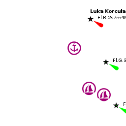
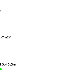
There are no dangers in the approach to Korcula Town from the W.
Warning: In the approach from E there are several ![]() islets [[Korčula (town)#islets|islets]] 42°57.124'N, 017°08.477'E and a
islets [[Korčula (town)#islets|islets]] 42°57.124'N, 017°08.477'E and a ![]() shoal patch [[Korčula (town)#shoal patch|shoal patch]] 42°57.551'N, 017°08.915'E being careful and paying attention to the chart is needed.
shoal patch [[Korčula (town)#shoal patch|shoal patch]] 42°57.551'N, 017°08.915'E being careful and paying attention to the chart is needed.
Entrance
Korčula (town) is a port of entry/exit for Croatia. For details see Entrance: Croatia.
Berthing

Town quay
With fresh to strong winds from the NE round to the SE, the quay on the NW side of Korcula old town offers much better shelter. Ferries and tripper boats use the outer section.
The small, recessed section next to the old tower of the town walls can be used by visiting yachts. There is room for 6-8 yachts to moor bows or stern-to using their anchors and taking lines ashore to the stainless steel staples along the quay.
Depths inside the recessed section are around 3.0 metres (at wall 2.2 m), out of it on the corner towards the beach the depths are 4.0 metres (at wall 3.0 metres). Holding is good in sand and weed. The shelter is good with S or E winds, but the quay is completely open from W round to N. There is a water pipe on the quay, but no electricity. Berthing fee HRK27 per metre + water and garbage HRK7 per metre.Marinas & Yacht Clubs
- Marina Korčula |- is situated immediately S of the old town and is partially sheltered from E winds by a long breakwater. The marina, which is open all year round, provides 159 berths for yachts of up to 40 metres (by advance arrangement) in depths of up to 6.0 metres. The shelter is good in all except strong SE winds, which cause an unpleasant swell in the marina. The marina quickly fills up during the busy months of July and August.
 – marina |
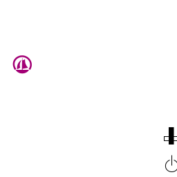
Anchorages

U. Luka
U. Luka is a popular anchorage in a long inlet immediately S of Korcula Town. It is close enough to walk into the town and is, therefore, a much cheaper alternative to Marina Korcula. In the approach from the E, note the ![]() shoal patch [[Korčula (town)#shoal patch|shoal patch]] 42°57.551'N, 017°08.915'E around 400 metres NE of the headland on the E side of the inlet.
shoal patch [[Korčula (town)#shoal patch|shoal patch]] 42°57.551'N, 017°08.915'E around 400 metres NE of the headland on the E side of the inlet.
Amenities
| Facilities | |
|---|---|
| Water |
|
| Electricity | |
| Toilets | In the Marina Korčula |
| Showers | In the Marina Korčula |
| Laundry | In the Marina Korčula |
| Garbage | Bins near the harbour and in the in the Marina Korčula |
| Supplies | |
| Fuel | |
| Bottled gas | None |
| Chandlers | |
| Services | |
| Repairs | |
| Internet | WiFi Marina Korčula and in several internet cafes |
| Mobile connectivity | Is there mobile telephone signal such as G4, G3, GPRS on the island? How strong is the signal? Are there any blind spots? |
| Vehicle rentals | |
| Health | |
Provisioning
![]() In the Town [[Korčula (town)#In the Town|In the Town]] Several supermarkets, butchers and other provisions.
In the Town [[Korčula (town)#In the Town|In the Town]] Several supermarkets, butchers and other provisions.
![]() In the Town [[Korčula (town)#In the Town|In the Town]] Fruit and vegetable market.
In the Town [[Korčula (town)#In the Town|In the Town]] Fruit and vegetable market.
![]() In the Town [[Korčula (town)#In the Town|In the Town]] Several shops sell the excellent local wines.
In the Town [[Korčula (town)#In the Town|In the Town]] Several shops sell the excellent local wines.
![]() Marina Korčula [[Korčula (town)#Marina Korčula|Marina Korčula]] Minimarket.
Marina Korčula [[Korčula (town)#Marina Korčula|Marina Korčula]] Minimarket.
Eating out
- In the Town
-
 [[Korčula (town)# | ]] Numerous restaurants and café/bar.
- [[Korčula (town)# | ]] Restaurant.
Transportation
- Frequent daily ferries to Orebic on the mainland
- Occasional ferries to Ancona in Italy (July to September only)
- Daily buses to Dubrovnik and Zagreb
- Local buses to Vela Luka and other local destinations
Tourism
The old town is fascinating to explore, its narrow, mediaeval streets lined with old stone houses dating back to the early Venetian occupation, many of them bearing beautiful ornamentation from the island’s master stone masons. The best-preserved section of the old town walls is on the W side, where three of the walls’ defensive towers still stand. The old town itself is entered through the Veliki Revelin, a 14th-century tower originally accessed via a wooden drawbridge. The cathedral square is dominated by the impressive 15th century St Mark’s Cathedral, with a finely sculpted entrance and soaring bell tower (the very narrow stairs of which can be climbed for a fee of 20 kuna). The interior (a charge is made) contains some further fine stone sculptures and a painting by the Venetian master Tintoretto. It is worth whiling away an hour or two in the Town Museum, sited in a 16th-century palace opposite the cathedral, which contains displays on Korcula’s stone masonry and shipbuilding activities as well as archaeological finds.
The Moreska, a traditional dance that has been performed in Korcula since the Middle Ages, is a local institution. With spectacular swordplay, it depicts the battles between its protagonist, the Red King, and antagonist, the Black King. The Moreska is performed every week during tourist season, usually on Monday nights, as well as on certain holidays. Tickets can be purchased at a variety of booths and newsagents throughout the city.


Links
- Korčula (town) at the Wikipedia
- Noonsite
- Korčula Tourist Board
For other useful websites, see Croatia.
References
See Croatia.
Comments
We welcome users' contributions to the Wiki. Please click on Comments to view other users' comments, add your own personal experiences or recommend any changes to this page following your visit.
Verified by
Date of member's last visit to Korčula (town) and this page's details validated:
- September 2012 --bm21
- July 2014 --Athene of Lymington
- August 2014 --Lotos
| This is a usable page of the cruising guide. However, please contribute if you can to help it grow further. Click on Comments to add your personal notes on this page or to discuss its contents. Alternatively, if you feel confident to edit the page, click on the edit tab at the top and enter your changes directly. |
| |
|---|
|
Names: Lighthouse, Athene of Lymington, Lotos |