Portoscuso
From CruisersWiki
m (bot: Move Offshore Islands) |
m (Text replace - "#References & Publications|" to "#References|") |
||
| (14 intermediate revisions not shown) | |||
| Line 1: | Line 1: | ||
{{IsPartOf|Mediterranean|Italy|Sardinia}} | {{IsPartOf|Mediterranean|Italy|Sardinia}} | ||
{{TOC block}} | {{TOC block}} | ||
| - | {{Infobox |39 | + | |
| - | | zoom= | + | {{Infobox |
| + | | lat= 39.19933| lon=8.38133 | ||
| + | | name= Portoscuso (Portu de Scusi) | ||
| + | | portofentry= | ||
| + | | zoom= 15 | ||
| + | | chartlet = y | ||
| image= Portoscuso.jpg | | image= Portoscuso.jpg | ||
| imagetext= Portoscuso harbour | | imagetext= Portoscuso harbour | ||
| - | }} | + | | summary= |
| - | + | | notes= | |
| + | | news= | ||
| + | }} | ||
| - | + | Portoscuso is a small town situated at the SW end of [[Sardinia]], about 50 miles west of [[Cagliari]] and five miles NE of the small island of San Pietro with its harbour of [[Carloforte]]. The town itself holds little to excite the yachting visitor, but the small port does have excellent berthing facilities on pontoons with water and electricity. | |
| - | + | ||
==Charts== | ==Charts== | ||
''See [[Sardinia#Charts|Sardinia]]''. | ''See [[Sardinia#Charts|Sardinia]]''. | ||
| - | == | + | ==Weather== |
| - | + | ''See [[Italy#Weather|Italy - weather]]''. | |
| - | + | ||
| - | '' | + | ==Passages== |
| + | ''See [[Mediterranean#Mediterranean_Passages|Mediterranean]]''. | ||
==Islands== | ==Islands== | ||
| - | * Isola di San Pietro - 5 miles | + | * [[San Pietro|Isola di San Pietro]] - 5 miles |
| - | * Isola di Sant'Antioco - 7 miles | + | * [[San Antioco|Isola di Sant'Antioco]] - 7 miles |
| - | == | + | ==Communication== |
| + | {{Green|Add here VHF channel for the coastguard, harbor masters. etc.}} | ||
| + | * | ||
| + | * | ||
| + | |||
| + | ''Also see [[HF_Radio|Cruiser's Nets]]'' | ||
| + | |||
| + | ==Navigation== | ||
Entry is safe in all conditions, although a heavy surf builds up with sustained NW winds. Beware of the tuna net which is often in place around Cape Altana NW of Portoscuso and the rocky shoals around Ghingetta lighthouse about a mile west of the harbour entrance. | Entry is safe in all conditions, although a heavy surf builds up with sustained NW winds. Beware of the tuna net which is often in place around Cape Altana NW of Portoscuso and the rocky shoals around Ghingetta lighthouse about a mile west of the harbour entrance. | ||
| - | ==Berthing | + | ==Berthing== |
| - | The harbour is managed by a private concessionaire, Saromar Gestioni. | + | The harbour is managed by a private concessionaire, Saromar Gestioni. |
===Marinas & Yacht Clubs=== | ===Marinas & Yacht Clubs=== | ||
| - | Currently the harbour offers a total of 385 berths on pontoons with depths from 3.0 to 4.5 metres. Yachts of up to 25.0 metres can be accommodated. Water and electricity at most berths. Small boat slipway (3T) and crane. | + | {{poi | lat= 39.20113 |lon=8.38114 |
| + | | type= marina | ||
| + | | name= Marina di Portoscuso | ||
| + | | altname= | ||
| + | | url = https://www.marinadicapitana.it/marina-portoscuso-berths | ||
| + | | zoom= 17 | ||
| + | | portofentry= | ||
| + | | image= | ||
| + | | imagetext= | ||
| + | | text= Currently the harbour offers a total of 385 berths on pontoons with depths from 3.0 to 4.5 metres. Yachts of up to 25.0 metres can be accommodated. Water and electricity at most berths. Small boat slipway (3T) and crane. | ||
| + | : {{email| [email protected]}}; Tel/Fax: {{phone|39|781|507 248}}; VHF channel 09 | ||
| + | : Address: Via Lungomare C.Colombo, Portoscuso, Sardinia, Italy | ||
| + | }} | ||
| - | + | ==Anchorages== | |
| - | Anchoring in the harbour is forbidden. | + | Anchoring in the harbour is forbidden. |
| - | + | The nearest safe anchorages in the prevailing northerly winds are on the south side of [[San Pietro]] island (about 12 miles). Also see [[Carloforte#Anchorages|Carloforte]] | |
| - | + | ||
| - | == | + | ==Amenities== |
| - | {{ | + | {{tlist |
| - | + | |header|Facilities | |
| - | + | ||
| - | + | |Water| Water on the pontoons | |
| - | + | |Electricity| Electricity on the pontoons | |
| - | + | |Toilets| {{MagentaText|?}} | |
| + | |Showers| {{MagentaText|?}} | ||
| + | |Laundry| {{MagentaText|?}} | ||
| + | |Garbage| Bins near the harbour | ||
| - | + | |header|Supplies | |
| - | + | |Fuel| Fuel can be delivered by tanker from station 500 m from the harbour | |
| + | |Bottled gas| {{MagentaText|?}} | ||
| + | |Chandlers| {{MagentaText|?}} | ||
| - | + | |header|Services | |
| - | + | |Repairs| Some engine and electrical repairs, but limited | |
| + | |Internet| {{MagentaText|?}} | ||
| + | |Mobile connectivity| {{MagentaText|?}} | ||
| + | |Vehicle rentals| {{MagentaText|?}} | ||
| + | }} | ||
| - | == | + | ==Provisioning== |
| - | + | Some provisions shops in the town. | |
| - | + | ||
| - | + | ||
| - | + | ||
| - | == | + | ==Eating out== |
| - | + | A couple of restaurants in the town. | |
| - | + | ==Transportation== | |
| - | + | ||
| - | + | ||
| - | + | ||
| - | + | ||
{{GreenText|List transportation (local and/or international.)}} | {{GreenText|List transportation (local and/or international.)}} | ||
| + | * | ||
| + | * | ||
| - | == | + | ==Tourism== |
| - | + | ====History==== | |
| - | + | The town dates from the late 16th century, when static fishing nets were established around the SW tip of Sardinia to trap the migrating tuna. | |
| - | == | + | ====Places to Visit==== |
| + | The town is quiet and unassuming, but there is little to hold the traveler. A so-called Spanish Tower on the promontory above the town dates from the 16th Spanish occupation when it was installed to protect the tuna nets. Around the town are several relics of its tuna fishing heyday, including the fortified space of Su Pranu which was formerly a centre of the fishing industry. | ||
| + | |||
| + | ==Friends== | ||
Contact details of "Cruiser's Friends" that can be contacted for local information or assistance. | Contact details of "Cruiser's Friends" that can be contacted for local information or assistance. | ||
* | * | ||
| - | == | + | ==Forums== |
List links to discussion threads on [[Cruising Forums|partnering forums]]. (''see link for requirements'') | List links to discussion threads on [[Cruising Forums|partnering forums]]. (''see link for requirements'') | ||
* | * | ||
| - | == | + | ==Links== |
* {{wikipedia}} | * {{wikipedia}} | ||
* | * | ||
| - | ==References | + | ==References== |
| - | ''See [[Italy#References | + | ''See [[Italy#References|Italy]]''. |
| - | {{Comments | + | {{Comments}} |
| + | * | ||
{{Verified by}} | {{Verified by}} | ||
| - | |||
* May 2003 --[[User:Atheneoflymington|Atheneoflymington]] 17:58, 18 February 2010 (UTC) | * May 2003 --[[User:Atheneoflymington|Atheneoflymington]] 17:58, 18 February 2010 (UTC) | ||
* | * | ||
| Line 101: | Line 131: | ||
{{Contributors|[[User:Lighthouse|Lighthouse]], [[User:Atheneoflymington|Athene of Lymington]]}} | {{Contributors|[[User:Lighthouse|Lighthouse]], [[User:Atheneoflymington|Athene of Lymington]]}} | ||
| - | [[Category:Ports - Italy]] [[Category:Marinas - Italy]] [[Category: | + | [[Category:Ports - Italy]] [[Category:Marinas - Italy]] [[Category:Marinas - Sardinia]] |
Latest revision as of 07:57, 21 August 2018
| Portoscuso (Portu de Scusi)
| |
| |
 Portoscuso harbour |
Portoscuso is a small town situated at the SW end of Sardinia, about 50 miles west of Cagliari and five miles NE of the small island of San Pietro with its harbour of Carloforte. The town itself holds little to excite the yachting visitor, but the small port does have excellent berthing facilities on pontoons with water and electricity.
Charts
See Sardinia.
Weather
See Italy - weather.
Passages
See Mediterranean.
Islands
- Isola di San Pietro - 5 miles
- Isola di Sant'Antioco - 7 miles
Communication
Add here VHF channel for the coastguard, harbor masters. etc.
Also see Cruiser's Nets
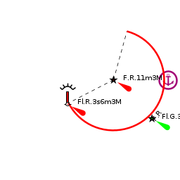
Entry is safe in all conditions, although a heavy surf builds up with sustained NW winds. Beware of the tuna net which is often in place around Cape Altana NW of Portoscuso and the rocky shoals around Ghingetta lighthouse about a mile west of the harbour entrance.
Berthing
The harbour is managed by a private concessionaire, Saromar Gestioni.
Marinas & Yacht Clubs
Marina di Portoscuso
Currently the harbour offers a total of 385 berths on pontoons with depths from 3.0 to 4.5 metres. Yachts of up to 25.0 metres can be accommodated. Water and electricity at most berths. Small boat slipway (3T) and crane.
- [email protected]; Tel/Fax: +39 (781) 507 248; VHF channel 09
- Address: Via Lungomare C.Colombo, Portoscuso, Sardinia, Italy
Anchorages
Anchoring in the harbour is forbidden.
The nearest safe anchorages in the prevailing northerly winds are on the south side of San Pietro island (about 12 miles). Also see Carloforte
Amenities
| Facilities | |
|---|---|
| Water | Water on the pontoons |
| Electricity | Electricity on the pontoons |
| Toilets | ? |
| Showers | ? |
| Laundry | ? |
| Garbage | Bins near the harbour |
| Supplies | |
| Fuel | Fuel can be delivered by tanker from station 500 m from the harbour |
| Bottled gas | ? |
| Chandlers | ? |
| Services | |
| Repairs | Some engine and electrical repairs, but limited |
| Internet | ? |
| Mobile connectivity | ? |
| Vehicle rentals | ? |
Provisioning
Some provisions shops in the town.
Eating out
A couple of restaurants in the town.
Transportation
List transportation (local and/or international.)
Tourism
History
The town dates from the late 16th century, when static fishing nets were established around the SW tip of Sardinia to trap the migrating tuna.
Places to Visit
The town is quiet and unassuming, but there is little to hold the traveler. A so-called Spanish Tower on the promontory above the town dates from the 16th Spanish occupation when it was installed to protect the tuna nets. Around the town are several relics of its tuna fishing heyday, including the fortified space of Su Pranu which was formerly a centre of the fishing industry.
Friends
Contact details of "Cruiser's Friends" that can be contacted for local information or assistance.
Forums
List links to discussion threads on partnering forums. (see link for requirements)
Links
- Portoscuso at the Wikipedia
References
See Italy.
Comments
We welcome users' contributions to the Wiki. Please click on Comments to view other users' comments, add your own personal experiences or recommend any changes to this page following your visit.
Verified by
Date of member's last visit to Portoscuso and this page's details validated:
- May 2003 --Atheneoflymington 17:58, 18 February 2010 (UTC)
| This is a usable page of the cruising guide. However, please contribute if you can to help it grow further. Click on Comments to add your personal notes on this page or to discuss its contents. Alternatively, if you feel confident to edit the page, click on the edit tab at the top and enter your changes directly. |
| |
|---|
|
Names: Lighthouse, Athene of Lymington |