Vrsar
From CruisersWiki
m (Text replace - "#References_.26_Publications|" to "#References|") |
Istioploos (Talk | contribs) m |
||
| (4 intermediate revisions not shown) | |||
| Line 1: | Line 1: | ||
| - | {{IsPartOf|Mediterranean|Adriatic Sea|Croatia}} | + | {{IsPartOf|Mediterranean|Adriatic Sea|Croatia|Istria}} |
{{TOC block}} | {{TOC block}} | ||
| - | {{Infobox |45 | + | |
| + | {{Infobox | ||
| + | | lat= 45.14962|lon=13.59833 | ||
| + | | name= Vrsar | ||
| + | | portofentry= | ||
| zoom= 15 | | zoom= 15 | ||
| + | | chartlet = y | ||
| image= Vrsar.JPG | | image= Vrsar.JPG | ||
| imagetext= Vrsar harbour from old town | | imagetext= Vrsar harbour from old town | ||
| - | | | + | | summary= The small town and harbour of '''Vrsar''' are situated five miles S of the harbour and marina of [[Porec]] and the same distance N of the harbour and marina of [[Rovinj]]. The harbour is protected from W and S by the island of Sveti Juraj, which has been joined to the mainland by an artificial barrier, and from N and NW by a harbour breakwater and (to some extent) by the small island of Galiner half a mile NW. Vrsar is a popular tourist resort and there are numerous holiday apartment complexes and campsites in the surrounding area. On the N side of the harbour is a 220 berth marina owned and operated by the Montraker leisure resort company, which also operates the small resort and marina of [[Marina Funtana]] 1.5 miles to the N. The marina also manages a pontoon on the S side of the harbour with laid moorings for around 10 yachts. Shelter is good in most conditions, although strong NW winds send in some swell. |
| - | + | | notes= | |
| - | The small town and harbour of Vrsar are situated five miles S of the harbour and marina of [[Porec]] and the same distance N of the harbour and marina of [[Rovinj]]. The harbour is protected from W and S by the island of Sveti Juraj, which has been joined to the mainland by an artificial barrier, and from N and NW by a harbour breakwater and (to some extent) by the small island of Galiner half a mile NW. Vrsar is a popular tourist resort and there are numerous holiday apartment complexes and campsites in the surrounding area. On the N side of the harbour is a 220 berth marina owned and operated by the Montraker leisure resort company, which also operates the small resort and marina of [[Marina Funtana]] 1.5 miles to the N. The marina also manages a pontoon on the S side of the harbour with laid moorings for around 10 yachts. Shelter is good in most conditions, although strong NW winds send in some swell. | + | | news= |
| + | }} | ||
==Charts== | ==Charts== | ||
; British Admiralty | ; British Admiralty | ||
| - | : | + | : BA201 |
| - | : | + | : BA204 |
; Croatian charts | ; Croatian charts | ||
: 100-15 | : 100-15 | ||
| Line 25: | Line 31: | ||
==Weather== | ==Weather== | ||
| - | + | ''See [[Croatia#Weather|Croatia]]''. | |
| - | + | ||
| - | + | ||
| - | + | ||
| - | + | ||
==Passages== | ==Passages== | ||
| Line 38: | Line 40: | ||
==Communication== | ==Communication== | ||
| - | + | {{Green|Add here VHF channel for the coastguard, harbor masters. etc.}} | |
* | * | ||
| + | * | ||
| + | |||
| + | ''Also see [[HF_Radio|Cruiser's Nets]]'' | ||
==Navigation== | ==Navigation== | ||
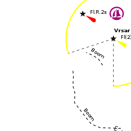
As with most of the towns in Istria, a conspicuous belfry in the town of Vrsar on a hill above the harbour at the head of the bay is identifiable from distance. There are numerous rocky islets off the coast in the approaches from both N and S and the safest option (unless you have a large scale chart) is to stay at least a mile offshore until the bay of Vrsar opens up to the N of Sv. Juraj island, which protects the bay from seaward. The bay is entered from NW, leaving the marked shoal of Mramori to starboard and small islet of Galiner to port. Entry via the shallow channel SE of Sv. Juraj island (through the artificial barrier) is prohibited as the area is buoyed off for swimming. The marina is installed along the northern shore of the bay and protected from NW by a long breakwater. The pontoon is on the S side of the harbour opposite the marina and next to the fishing boat berths. Depths in the harbour range from 4.0 - 12.0 metres, the deeper water being towards the end of the first pier of the marina and the breakwater. | As with most of the towns in Istria, a conspicuous belfry in the town of Vrsar on a hill above the harbour at the head of the bay is identifiable from distance. There are numerous rocky islets off the coast in the approaches from both N and S and the safest option (unless you have a large scale chart) is to stay at least a mile offshore until the bay of Vrsar opens up to the N of Sv. Juraj island, which protects the bay from seaward. The bay is entered from NW, leaving the marked shoal of Mramori to starboard and small islet of Galiner to port. Entry via the shallow channel SE of Sv. Juraj island (through the artificial barrier) is prohibited as the area is buoyed off for swimming. The marina is installed along the northern shore of the bay and protected from NW by a long breakwater. The pontoon is on the S side of the harbour opposite the marina and next to the fishing boat berths. Depths in the harbour range from 4.0 - 12.0 metres, the deeper water being towards the end of the first pier of the marina and the breakwater. | ||
| - | |||
| - | |||
| - | |||
==Berthing== | ==Berthing== | ||
| - | {{ | + | {{poi |45.14889|lon=13.60045 |
| - | + | | type= harbour | |
| - | + | | name=Town quay pontoon | |
| - | + | | url= | |
| + | | zoom=16 | ||
| + | | image= VrsarPontoon.JPG | ||
| + | | imagetext= The pontoon on the S quay | ||
| + | | text=The pontoon on the S side of the harbour has laid moorings for up to 10 yachts in depths of 3.0 – 4.0 metres. Water and electricity is available. Berths here are managed by the marina. Shelter is less good and the berths are very noisy from nearby cafes. | ||
| + | }} | ||
| - | === | + | {{hold vertical}} |
| - | {{ | + | ===Marinas & Yacht Clubs=== |
| - | [[Marina Vrsar]] offers 220 berths in total for yachts up to 50 metres and in depths of up to 12.0 metres. Click on the link for details. Shelter is excellent in most conditions, although there is some swell in strong NW winds. | + | {{poi | lat= 45.14989|lon=13.60044 |
| + | | type= marina | ||
| + | | name=[[Marina Vrsar]] | ||
| + | | altname= | ||
| + | | url = | ||
| + | | zoom= 16 | ||
| + | | portofentry= | ||
| + | | image= MarinaVrsar.JPG | ||
| + | | imagetext= Marina Vrsar | ||
| + | | text= offers 220 berths in total for yachts up to 50 metres and in depths of up to 12.0 metres. Click on the link for details. Shelter is excellent in most conditions, although there is some swell in strong NW winds. | ||
| + | }} | ||
| - | + | {{poi | lat= 45.12747|lon=13.62343 | |
| - | {{ | + | | type= marina |
| - | The | + | | name= Marina Valalta |
| + | | altname= | ||
| + | | url = http://valalta.hr/en/ | ||
| + | | zoom= 17 | ||
| + | | portofentry= | ||
| + | | image= | ||
| + | | imagetext= | ||
| + | | text= The Valalta Marina is the first and only harbour for naturists in the Adriatic. It offers its guests servicing facilities with raising and lowering of boats as well as sanitary facilities with warm and cold water. There are also water and power connections at dockside and a slipway for boats. Restaurant and bar. | ||
| + | : {{email|[email protected]}}; Tel: {{phone|385|52|804 800}}; Fax: {{fax|385|52|821 004}}; VHF channel XX | ||
| + | : Address: Valalta d.o.o., Cesta za Valaltu - Lim 7, 52210 Rovinj - Istra, Croatia | ||
| + | : Hours: Open summer only. | ||
| + | }} | ||
| - | === | + | {{poi | lat= 45.177313|lon=13.598101 |
| - | + | | type= marina | |
| + | | name= [[Marina Funtana]] | ||
| + | | altname= | ||
| + | | url = | ||
| + | | zoom= 16 | ||
| + | | portofentry= | ||
| + | | image= | ||
| + | | imagetext= | ||
| + | | text= The marina is 1.5 nM north of the harbour of [[#Town quay pontoon|Vrsar]]. Full facilities. | ||
| + | }} | ||
| - | + | {{hold vertical}} | |
| - | == | + | ==Anchorage== |
| - | + | {{Warning}}Anchoring in Vrsar harbour is prohibited except in case of emergency. | |
| - | + | ||
| - | ==== | + | {{poi |45.15785|lon=13.60678 |
| - | + | | type=anchorage | |
| + | | name=bay N of Vrsar | ||
| + | | zoom= 15 | ||
| + | | url= | ||
| + | | image= VrsarAnchorage.JPG | ||
| + | | imagetext= The anchorage from the church belltower | ||
| + | | text=There is a very attractive and sheltered anchorage in the bay N of the town, protected from all directions except SW by the islands of Salamun and Cavata. Depths here are 3.0 – 5.0 metres and the holding is good in sand and mud. Shelter is excellent in all but strong winds from W round to SW (when, if your draft permits, you may be able to re-anchor further N in the bay). | ||
| + | }} | ||
| - | == | + | ==Amenities== |
| - | + | {{tlist | |
| - | + | ||
| - | + | ||
| - | + | ||
| - | {{ | + | |
| - | + | ||
| - | + | ||
| - | + | |header|Facilities | |
| - | + | ||
| - | + | |Water| In the [[#Town quay pontoon|Town quay pontoons]], the [[Marina Vrsar]], the [[#Marina Valalta|Marina Valalta]], and the [[Marina Funtana]] | |
| - | + | |Electricity| In the [[#Town quay pontoon|Town quay pontoons]], the [[Marina Vrsar]], the [[#Marina Valalta|Marina Valalta]], and the [[Marina Funtana]] | |
| - | + | |Toilets| In the [[Marina Vrsar]], the [[#Marina Valalta|Marina Valalta]], and the [[Marina Funtana]] | |
| + | |Showers| In the [[Marina Vrsar]], the [[#Marina Valalta|Marina Valalta]], and the [[Marina Funtana]] | ||
| + | |Laundry| In the [[Marina Vrsar]] (coin operated), the [[#Marina Valalta|Marina Valalta]], and the [[Marina Funtana]] | ||
| + | |Garbage| Bins in the marinas and near the town quay | ||
| - | + | |header|Supplies | |
| - | + | |Fuel| Fuel dock at E end of the harbour (depth of 3.0 – 4.0 metres) | |
| + | |Bottled gas| {{MagentaText|?}} | ||
| + | |Chandlers| Small chandlery in the [[Marina Vrsar]] | ||
| - | + | |header|Services | |
| - | + | |Repairs| Basic repairs in the [[Marina Vrsar]] and the [[Marina Funtana]] | |
| + | |Internet| WiFi in the [[Marina Vrsar]] and the [[Marina Funtana]] | ||
| + | |Mobile connectivity| {{MagentaText|?}} | ||
| + | |Vehicle rentals| Rental outlets in the town | ||
| + | }} | ||
| - | == | + | ==Provisioning== |
| - | + | * Minimarket in the [[Marina Vrsar]] (very mini) and in the [[Marina Funtana]] | |
| + | * Supermarket one street back from the town quay | ||
| - | == | + | ==Eating out== |
| - | + | * Restaurant and Café/bar in the [[Marina Vrsar]] | |
| + | * Restaurant and bar in the [[#Marina Valalta|Marina Valalta]] | ||
| + | * Café/bistro in the [[Marina Funtana]] | ||
| + | * Numerous bars and restaurants in the town | ||
| - | + | ==Transportation== | |
* Buses to [[Rovinj]], [[Pula]] and other local destinations. | * Buses to [[Rovinj]], [[Pula]] and other local destinations. | ||
* International airport at [[Pula]] 42 kms. | * International airport at [[Pula]] 42 kms. | ||
* High speed ferry (summer only) to Venice. | * High speed ferry (summer only) to Venice. | ||
| + | |||
| + | ===Tourism=== | ||
| + | {{Image right|VrsarTown.JPG |Vrsar old town from marina }} | ||
| + | {{Image right|VrsarOldTown.JPG |Remains of the old town walls }} | ||
| + | ====History==== | ||
| + | {{Green|Give a short history of the port.}} | ||
| + | |||
| + | ====Places to Visit==== | ||
| + | Vrsar is in a charming setting, its old town perched on a hill and surrounded by thickly forested hills. While not as picturesque as some of the other Istrian towns, Vrsar has its share of narrow alleyways and colourful squares and is less thronged with tourists than its bigger neighbours, [[Porec]] and [[Rovinj]]. The church belltower can be climbed at a cost of HRK10 and repays the effort with superb views over the harbour and surrounding bays. There are several cycle trails that wind through leafy byways into the surrounding countryside. | ||
==Friends== | ==Friends== | ||
| Line 114: | Line 172: | ||
==Links== | ==Links== | ||
| + | * {{Wikipedia}} | ||
| + | * {{Wikivoyage}} | ||
| + | * [http://www.noonsite.com/Countries/Croatia/Vrsar Noonsite] | ||
* [http://www.istra.hr/en/regions_and_towns/town_and_cities/ Istria Tourism website] | * [http://www.istra.hr/en/regions_and_towns/town_and_cities/ Istria Tourism website] | ||
| Line 121: | Line 182: | ||
''See entry for [[Croatia#References|Croatia]]''. | ''See entry for [[Croatia#References|Croatia]]''. | ||
| - | {{Comments | + | {{Comments}} |
* | * | ||
| Line 134: | Line 195: | ||
{{Contributors| [[User:Atheneoflymington|Athene of Lymington]], }} | {{Contributors| [[User:Atheneoflymington|Athene of Lymington]], }} | ||
| - | [[Category:Ports - Croatia]] | + | [[Category:Ports - Croatia]] [[Category:Marinas - Croatia]] [[Category:Anchorages - Croatia]] |
Latest revision as of 21:42, 22 February 2019
| Vrsar
| |
| |
 Vrsar harbour from old town |
The small town and harbour of Vrsar are situated five miles S of the harbour and marina of Porec and the same distance N of the harbour and marina of Rovinj. The harbour is protected from W and S by the island of Sveti Juraj, which has been joined to the mainland by an artificial barrier, and from N and NW by a harbour breakwater and (to some extent) by the small island of Galiner half a mile NW. Vrsar is a popular tourist resort and there are numerous holiday apartment complexes and campsites in the surrounding area. On the N side of the harbour is a 220 berth marina owned and operated by the Montraker leisure resort company, which also operates the small resort and marina of Marina Funtana 1.5 miles to the N. The marina also manages a pontoon on the S side of the harbour with laid moorings for around 10 yachts. Shelter is good in most conditions, although strong NW winds send in some swell.
Charts
- British Admiralty
- BA201
- BA204
- Croatian charts
- 100-15
- 100-16
- 11
- Italian charts
- 924
- 39
- 6002
- Imray Nautical Chart
- M24
Weather
See Croatia.
Passages
See Croatia.
Islands
Numerous.
Communication
Add here VHF channel for the coastguard, harbor masters. etc.
Also see Cruiser's Nets
As with most of the towns in Istria, a conspicuous belfry in the town of Vrsar on a hill above the harbour at the head of the bay is identifiable from distance. There are numerous rocky islets off the coast in the approaches from both N and S and the safest option (unless you have a large scale chart) is to stay at least a mile offshore until the bay of Vrsar opens up to the N of Sv. Juraj island, which protects the bay from seaward. The bay is entered from NW, leaving the marked shoal of Mramori to starboard and small islet of Galiner to port. Entry via the shallow channel SE of Sv. Juraj island (through the artificial barrier) is prohibited as the area is buoyed off for swimming. The marina is installed along the northern shore of the bay and protected from NW by a long breakwater. The pontoon is on the S side of the harbour opposite the marina and next to the fishing boat berths. Depths in the harbour range from 4.0 - 12.0 metres, the deeper water being towards the end of the first pier of the marina and the breakwater.
Berthing

Town quay pontoon
Marinas & Yacht Clubs

Marina Vrsar
Marina Valalta
The Valalta Marina is the first and only harbour for naturists in the Adriatic. It offers its guests servicing facilities with raising and lowering of boats as well as sanitary facilities with warm and cold water. There are also water and power connections at dockside and a slipway for boats. Restaurant and bar.
- [email protected]; Tel: +385 (52) 804 800; Fax: +385 (52) 821 004; VHF channel XX
- Address: Valalta d.o.o., Cesta za Valaltu - Lim 7, 52210 Rovinj - Istra, Croatia
- Hours: Open summer only.
Marina Funtana
Anchorage
Warning: Anchoring in Vrsar harbour is prohibited except in case of emergency.

bay N of Vrsar
Amenities
| Facilities | |
|---|---|
| Water | In the Town quay pontoons, the Marina Vrsar, the Marina Valalta, and the Marina Funtana |
| Electricity | In the Town quay pontoons, the Marina Vrsar, the Marina Valalta, and the Marina Funtana |
| Toilets | In the Marina Vrsar, the Marina Valalta, and the Marina Funtana |
| Showers | In the Marina Vrsar, the Marina Valalta, and the Marina Funtana |
| Laundry | In the Marina Vrsar (coin operated), the Marina Valalta, and the Marina Funtana |
| Garbage | Bins in the marinas and near the town quay |
| Supplies | |
| Fuel | Fuel dock at E end of the harbour (depth of 3.0 – 4.0 metres) |
| Bottled gas | ? |
| Chandlers | Small chandlery in the Marina Vrsar |
| Services | |
| Repairs | Basic repairs in the Marina Vrsar and the Marina Funtana |
| Internet | WiFi in the Marina Vrsar and the Marina Funtana |
| Mobile connectivity | ? |
| Vehicle rentals | Rental outlets in the town |
Provisioning
- Minimarket in the Marina Vrsar (very mini) and in the Marina Funtana
- Supermarket one street back from the town quay
Eating out
- Restaurant and Café/bar in the Marina Vrsar
- Restaurant and bar in the Marina Valalta
- Café/bistro in the Marina Funtana
- Numerous bars and restaurants in the town
Transportation
- Buses to Rovinj, Pula and other local destinations.
- International airport at Pula 42 kms.
- High speed ferry (summer only) to Venice.
Tourism


History
Give a short history of the port.
Places to Visit
Vrsar is in a charming setting, its old town perched on a hill and surrounded by thickly forested hills. While not as picturesque as some of the other Istrian towns, Vrsar has its share of narrow alleyways and colourful squares and is less thronged with tourists than its bigger neighbours, Porec and Rovinj. The church belltower can be climbed at a cost of HRK10 and repays the effort with superb views over the harbour and surrounding bays. There are several cycle trails that wind through leafy byways into the surrounding countryside.
Friends
Contact details of "Cruiser's Friends" that can be contacted for local information or assistance.
Forums
List links to discussion threads on partnering forums. (see link for requirements)
Links
- Vrsar at the Wikipedia
- Vrsar at the Wikivoyage
- Noonsite
- Istria Tourism website
For other useful websites, see Croatia.
References
See entry for Croatia.
Comments
We welcome users' contributions to the Wiki. Please click on Comments to view other users' comments, add your own personal experiences or recommend any changes to this page following your visit.
Verified by
Date of member's last visit to Vrsar and this page's details validated:
- June 2015 --Athene of Lymington
| This is a usable page of the cruising guide. However, please contribute if you can to help it grow further. Click on Comments to add your personal notes on this page or to discuss its contents. Alternatively, if you feel confident to edit the page, click on the edit tab at the top and enter your changes directly. |
| |
|---|
|
Names: Athene of Lymington, |