Mediterranean
From CruisersWiki
Istioploos (Talk | contribs) m (→Major Seas in The Mediterranean: Updated) |
Istioploos (Talk | contribs) (Interactive Maps) |
||
| Line 2: | Line 2: | ||
An online cruising guide for yachts sailing the coasts and islands in the Mediterranean Sea. | An online cruising guide for yachts sailing the coasts and islands in the Mediterranean Sea. | ||
| - | [[Image: | + | ==Map of the Mediterranean== |
| + | ''For more details click on the map, for wiki pages click on the links below:'' | ||
| + | |||
| + | <imagemap> | ||
| + | Image:MedMap.jpg|frame|center|Map of the Mediterranean - ''Click on a name or an area'' | ||
| + | rect 7 197 60 220 [[Gibraltar]] | ||
| + | rect 12 246 80 271 [[Morocco]] | ||
| + | poly 72 12 220 102 142 205 71 200 11 157 [[Spain]] | ||
| + | rect 208 123 247 150 [[Balearic Sea]] | ||
| + | rect 120 240 300 290 [[Algeria]] | ||
| + | rect 208 155 227 180 [[Ibiza]] | ||
| + | poly 253 141 290 170 233 170 240 153 [[Majorca]] | ||
| + | poly 254 123 307 123 307 154 279 153 254 137 [[Menorca]] | ||
| + | rect 327 40 370 64 [[Monaco]] | ||
| + | poly 192 31 210 1 367 1 366 43 323 43 272 61 [[France]] | ||
| + | rect 370 70 415 120 [[Corsica]] | ||
| + | rect 361 121 413 192 [[Sardinia]] | ||
| + | rect 333 233 428 331 [[Tunisia]] | ||
| + | poly 421 99 495 160 493 200 427 200 [[Tyrrhenian Coast|Tyrrhenian Sea]] | ||
| + | poly 368 15 504 1 510 33 475 25 492 65 547 132 597 169 537 233 550 231 538 190 420 80 416 43 385 37 [[Italy]] | ||
| + | poly 451 216 525 217 517 269 450 235 [[Sicily]] | ||
| + | rect 475 270 520 315 [[Malta]] | ||
| + | rect 508 13 560 33 [[Slovenia]] | ||
| + | poly 516 38 590 60 600 103 558 92 550 83 553 80 [[Croatia]] | ||
| + | rect 600 86 680 112 [[Bosnia and Herzegovina]] | ||
| + | rect 587 113 657 133 [[Montenegro]] | ||
| + | poly 614 134 635 139 633 160 622 172 [[Albania]] | ||
| + | poly 593 165 542 116 493 66 467 35 470 16 488 11 547 83 607 134 609 177 [[Adriatic Sea]] | ||
| + | poly 616 180 667 147 747 141 703 173 685 160 693 190 726 230 707 250 700 285 656 266 632 224 [[Greece]] | ||
| + | poly 593 170 609 170 647 223 657 277 517 273 [[Ionian Sea]] | ||
| + | poly 756 165 812 165 806 136 900 102 900 272 818 268 784 252 774 226 761 223 772 212 800 204 756 187 767 189 [[Turkey]] | ||
| + | rect 468 337 730 500 [[Libya]] | ||
| + | rect 738 375 900 500 [[Egypt]] | ||
| + | rect 697 286 768 357 [[Crete]] | ||
| + | rect 790 60 900 115 [[Black Sea]] | ||
| + | rect 760 140 812 164 [[Sea of Marmara]] | ||
| + | poly 747 154 750 190 766 193 762 205 754 207 758 227 774 232 778 257 784 258 776 268 806 268 800 306 700 290 715 242 690 204 682 166 713 154 [[Aegean Map]] | ||
| + | rect 838 321 900 355 [[#Map of East Mediterranean|East Mediterranean]] | ||
| + | </imagemap> | ||
| + | <!-- rect 77 200 124 238 [[Alboran Sea]] --> | ||
| + | <div style="clear: both;"></div> | ||
| + | |||
| + | ==Map of East Mediterranean== | ||
| + | ''For more details click on the map, for wiki pages click on the links below:'' | ||
| + | |||
| + | <imagemap> | ||
| + | Image:East_MedMap.jpg|frame|center|Map of East Mediterranean - ''Click on a name or an area'' | ||
| + | poly 70 2 76 33 58 36 54 55 66 67 88 73 85 88 89 113 102 129 122 135 180 156 186 158 420 110 420 1 [[Turkey]] | ||
| + | rect 1 1 125 196 [[Aegean Map]] | ||
| + | rect 413 132 510 185 [[Syria]] | ||
| + | rect 375 193 457 230 [[Lebanon]] | ||
| + | poly 260 200 368 162 355 212 327 255 260 255 [[Cyprus]] | ||
| + | rect 320 273 402 380 [[Israel]] | ||
| + | rect 120 325 330 500 [[Egypt]] | ||
| + | rect 1 259 74 305 [[#Map of the Mediterranean|West Mediterranean]] | ||
| + | </imagemap> | ||
| + | |||
{{TOCleft}} | {{TOCleft}} | ||
The [http://en.wikipedia.org/wiki/Mediterranean Mediterranean] Sea is a sea off the [[North Atlantic|Atlantic Ocean]] surrounded by the Mediterranean region and almost completely enclosed by land: on the north by Europe, on the south by [[Africa]], and on the east by Asia. It covers an approximate area of 2.5 million km<sup>2</sup> (965,000 sq mi) and and it is approximate 2,080 nM (3,860 km) long, but its connection to the [[North Atlantic|Atlantic]] (the Strait of Gibraltar) is only 7.6 nM (14 km) wide. Its average depth of 1,500 metres (4,920 ft) and the deepest recorded point is 5,267 meters (about 3.27 miles) in the ''Calypso Deep'' in the [[Ionian Sea]]. The Mediterranean coastline extends for 24,800 nM (46,000 km or 28,600 mi). In oceanography, it is sometimes called the ''Eurafrican Mediterranean Sea'' or the ''European Mediterranean Sea'' to distinguish it from mediterranean seas elsewhere. | The [http://en.wikipedia.org/wiki/Mediterranean Mediterranean] Sea is a sea off the [[North Atlantic|Atlantic Ocean]] surrounded by the Mediterranean region and almost completely enclosed by land: on the north by Europe, on the south by [[Africa]], and on the east by Asia. It covers an approximate area of 2.5 million km<sup>2</sup> (965,000 sq mi) and and it is approximate 2,080 nM (3,860 km) long, but its connection to the [[North Atlantic|Atlantic]] (the Strait of Gibraltar) is only 7.6 nM (14 km) wide. Its average depth of 1,500 metres (4,920 ft) and the deepest recorded point is 5,267 meters (about 3.27 miles) in the ''Calypso Deep'' in the [[Ionian Sea]]. The Mediterranean coastline extends for 24,800 nM (46,000 km or 28,600 mi). In oceanography, it is sometimes called the ''Eurafrican Mediterranean Sea'' or the ''European Mediterranean Sea'' to distinguish it from mediterranean seas elsewhere. | ||
Revision as of 18:38, 13 February 2015
The Mediterranean Sea Cruising Guide
An online cruising guide for yachts sailing the coasts and islands in the Mediterranean Sea.
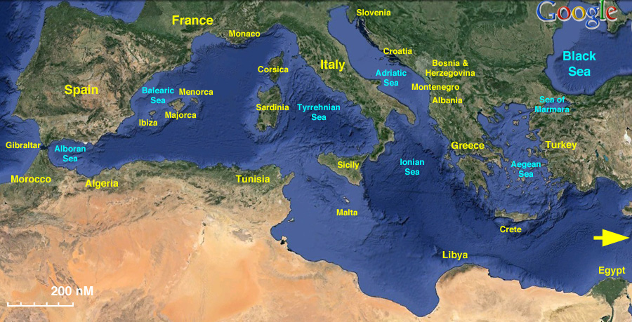
Map of the Mediterranean
For more details click on the map, for wiki pages click on the links below:

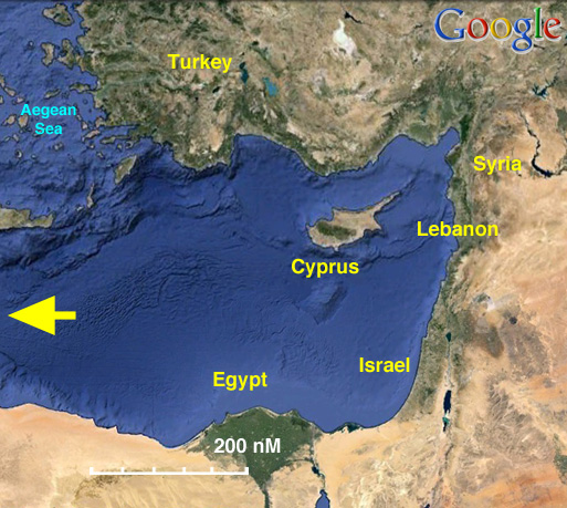
Map of East Mediterranean
For more details click on the map, for wiki pages click on the links below:

The Mediterranean Sea is a sea off the Atlantic Ocean surrounded by the Mediterranean region and almost completely enclosed by land: on the north by Europe, on the south by Africa, and on the east by Asia. It covers an approximate area of 2.5 million km2 (965,000 sq mi) and and it is approximate 2,080 nM (3,860 km) long, but its connection to the Atlantic (the Strait of Gibraltar) is only 7.6 nM (14 km) wide. Its average depth of 1,500 metres (4,920 ft) and the deepest recorded point is 5,267 meters (about 3.27 miles) in the Calypso Deep in the Ionian Sea. The Mediterranean coastline extends for 24,800 nM (46,000 km or 28,600 mi). In oceanography, it is sometimes called the Eurafrican Mediterranean Sea or the European Mediterranean Sea to distinguish it from mediterranean seas elsewhere.

The Mediterranean Sea is connected to the Atlantic Ocean by the Strait of Gibraltar on the west and to the Sea of Marmara and the Black Sea, by the Dardanelles and the Bosphorus respectively, on the east. The Sea of Marmara is often considered a part of the Mediterranean Sea, whereas the Black Sea is generally not. The 88 nM (163 km) long man-made Suez Canal in the southeast connects the Mediterranean Sea to the Red Sea.
Being nearly landlocked affects the Mediterranean Sea's properties; for instance, tides are very limited as a result of the narrow connection with the Atlantic Ocean. The Mediterranean is characterized and immediately recognized by its deep blue color.
Evaporation greatly exceeds precipitation and river runoff in the Mediterranean, a fact that is central to the water circulation within the basin. Evaporation is especially high in its eastern half, causing the water level to decrease and salinity to increase eastward. This pressure gradient pushes relatively cool, low-salinity water from the Atlantic across the basin; it warms and becomes saltier as it travels east, then sinks in the region of the Levant and circulates westward, to spill over the Strait of Gibraltar. Thus, seawater flow is eastward in the Strait's surface waters, and westward below; once in the Atlantic, this chemically-distinct Mediterranean Intermediate Water can persist thousands of kilometers away from its source.
Mediterranean Cruising permits/Requirements
- See Med Cruising Regs - for details of what is required for both the yacht (EU registered & non-EU) and crew (EU passports & non-EU)
- Schengen Visas - Official Website - for the OFFICIAL requirements for Schengen countries
Mediterranean Climate
The Mediterranean climate is characterized by hot, dry summers and cool, wet winters.
Sources for weather forecasts for the Mediteranean:
- Wind Guru A surfer's site with worldwide wind forecasts
- Frank Singleton's weather page
- Passage weather Worldwide Weather Maps
- Weather on Line provides detailed 7 day forecast charts for the Mediterranean, Northern Europe and the Atlantic
- France Coastal weather from MeteoFrance
- Spain Coastal weather from AEMet
- Italy Coastal weather from Il Meteo
- Athens Observatory Gives 3 day (every 6 hrs) detail graphical forecasts for the Greek Seas
- GRIB.US Free download software to access and visualise GRIB data, easy to use.
- zyGrib Free download software to access and visualise GRIB data. Less easy to use but more flexible than grib.us
Mediterranean Charts
- BA
- 4300 Mediterranean and Black Sea
- 4301 Mediterranean — western part
- Mediterranean — eastern part
- NIMA
- W310 Mediterranean Sea
- Turkish
- 2 Mediterranean
See also NIMA Pub. 132 - Eastern Mediterranean.
Radio Nets
Also see World Cruiser's Nets.
Countries in The Mediterranean
Clockwise starting from Gibraltar
![]() = Featured article,
= Featured article, ![]() = Article/page link needs more data.
= Article/page link needs more data.
Major Islands in The Mediterranean
Major Seas in The Mediterranean
Routes/Passages To/From
These passages can be used for both East to West and for West to East voyages.
See also Mediterranean Distances Table.
Cruiser's Friends
Contact details of "Cruiser's Friends" that can be contacted for local information or assistance.
Forum Discussions
List links to discussion threads on partnering forums. (see link for requirements)
External Links
- Mediterranean - Wikipedia
References & Publications
- Rod Heikell, Mediterranean Cruising Handbook, Imray Laurie Norie & Wilson; 6th Revised edition edition (April 21, 2012), ISBN 978-1846231704
- Rod Heikel and Lu Michell, Mediterranean Almanac, Imray Laurie and Wilson, Cambridgeshire, ISBN 9781846230837
- RCC Pilotage Foundation, John Marchment, Mediterranean Spain - Costa del Sol and Blanca, Imray Laurie Norie & Wilson; 6th Revised edition edition (July 20, 2009), ISBN 9781846231834
- Graham Hutt and RCC Pilotage Foundation, North Africa, including Morocco, Algeria, Libya, Tunisia, Gibraltar, Pantelleria and the Pelagie Islands and Malta, Imray, Laurie, Norie & Wilson, Cambridgeshire, Updated 2010 , ISBN 9781846232817
- Rod Heikell, Mediterranean France & Corsica Pilot, Imray Laurie Norie & Wilson; 4th ed. edition (March 14, 2008), ISBN 9780852889695
- Rod Heikell, Italian Waters Pilot, Imray, Laurie, Norie & Wilson, Cambridgeshire, Updated Edition 8th (2011), ISBN 9781846233326 - Covers the coasts of the Tyrrhenian Sea, Sardinia, Sicily, the Ionian 'heel' and Malta
- Trevor and Dinah Thompson, Adriatic Pilot - Croatia, Slovenia, Montenegro, East coast of Italy and Albania, Imray Laurie Norie & Wilson; 6th Revised edition edition (March 1, 2012), ISBN 9781846233333
- Rod Heikell, Greek Waters Pilot, Imray Laurie Norie & Wilson; 11th Revised edition edition (July 30, 2011), ISBN 9781846233340
- Rod Heikell, Turkish Waters & Cyprus Pilot, Imray,Laurie,Norie & Wilson Ltd; 8th edition (April 1, 2009), ISBN 9781846231889
Personal Notes
Personal experiences?
|
|---|
|
Names: Lighthouse, Nausikaa, JeanneP, Istioploos, Atheneoflymington |
| |
|---|
| | HOMEPAGE | Wiki Contents | Mediterranean | |