Alboran Sea
From CruisersWiki
m (Text replace - "==Communication== * * ''Also see World Cruiser's Nets''. " to "==Communication== * ''Also see World Cruiser's Nets''. ") |
|||
| (13 intermediate revisions not shown) | |||
| Line 2: | Line 2: | ||
|isNot2=y|isNot3=y|isNot4=y|isNot5=y | |isNot2=y|isNot3=y|isNot4=y|isNot5=y | ||
}} | }} | ||
| - | |||
| - | |||
| - | |||
| - | |||
| - | |||
| - | |||
| - | |||
| - | |||
| - | |||
| - | |||
| - | |||
| - | |||
| - | |||
| - | |||
| - | |||
| - | |||
| - | |||
{{TOC block}} | {{TOC block}} | ||
| + | {{Page imagemap|clear=y}} | ||
| + | |||
The Alboran Sea is the westernmost portion of the Mediterranean Sea. It extends from the strait of [[Gibraltar]] on the west to [[Almeria]], in [[Spain]] on the NE and [[Algeria]] on the SE. | The Alboran Sea is the westernmost portion of the Mediterranean Sea. It extends from the strait of [[Gibraltar]] on the west to [[Almeria]], in [[Spain]] on the NE and [[Algeria]] on the SE. | ||
| - | == | + | ==Charts== |
; British Admiralty (BA) | ; British Admiralty (BA) | ||
: 773 Straight of Gibraltar to Isla Alborán | : 773 Straight of Gibraltar to Isla Alborán | ||
| Line 35: | Line 20: | ||
: 52049 Almeria, Carboneras and Approaches: 52120 Vilaroz to Cabo Creus | : 52049 Almeria, Carboneras and Approaches: 52120 Vilaroz to Cabo Creus | ||
: 52120 Vilaroz to Cabo Creus | : 52120 Vilaroz to Cabo Creus | ||
| - | |||
| - | ==Weather | + | ==Weather== |
| - | ''See [[Spain# | + | ''See [[Spain#Weather|Spain]]''. |
| - | ==Currents & Tides== | + | ====Currents & Tides==== |
| - | ''See [[Gibraltar# | + | ''See [[Gibraltar#Navigation|Gibraltar]]''. |
| - | == | + | ==Passages== |
| - | + | ''See [[Aegean to West Mediterranean Passages]]''. | |
| - | == | + | ''See also [[Mediterranean Distances Table]]''. |
| - | + | ||
| + | ==Communication== | ||
* | * | ||
''Also see [[World MM Nets|World Cruiser's Nets]]''. | ''Also see [[World MM Nets|World Cruiser's Nets]]''. | ||
| + | ==Navigation== | ||
| + | {{GreenText|Any navigation notes here. If this section does not apply remove it.}} | ||
==Countries, Ports, Anchorages, and Islands== | ==Countries, Ports, Anchorages, and Islands== | ||
| Line 65: | Line 52: | ||
* [[Algeria]] | * [[Algeria]] | ||
| - | == | + | ==Friends== |
| - | + | ||
| - | + | ||
| - | + | ||
| - | + | ||
| - | + | ||
Contact details of "Cruiser's Friends" that can be contacted for local information or assistance. | Contact details of "Cruiser's Friends" that can be contacted for local information or assistance. | ||
* | * | ||
| - | == | + | ==Forums== |
List links to discussion threads on [[Cruising Forums|partnering forums]]. (''see link for requirements'') | List links to discussion threads on [[Cruising Forums|partnering forums]]. (''see link for requirements'') | ||
* | * | ||
| - | == | + | ==Links== |
| - | * | + | * {{wikipedia}} |
| + | * | ||
| - | ==References | + | ==References== |
* {{Reference|Graham Hutt and RCC Pilotage Foundation|[http://www.amazon.com/North-Africa-Including-Gibraltar-Pantelleria/dp/1846232813 North Africa, including Morocco, Algeria, Libya, Tunisia, Gibraltar, Pantelleria and the Pelagie Islands and Malta]|Imray, Laurie, Norie & Wilson, Cambridgeshire, Updated 2010 |9781846232817}} | * {{Reference|Graham Hutt and RCC Pilotage Foundation|[http://www.amazon.com/North-Africa-Including-Gibraltar-Pantelleria/dp/1846232813 North Africa, including Morocco, Algeria, Libya, Tunisia, Gibraltar, Pantelleria and the Pelagie Islands and Malta]|Imray, Laurie, Norie & Wilson, Cambridgeshire, Updated 2010 |9781846232817}} | ||
''See also [[Spain#Mediterranean|Spain]]''. | ''See also [[Spain#Mediterranean|Spain]]''. | ||
| - | + | {{Comments}} | |
| - | + | ||
* | * | ||
Latest revision as of 10:01, 22 August 2018
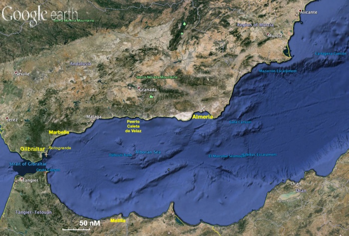  |
The Alboran Sea is the westernmost portion of the Mediterranean Sea. It extends from the strait of Gibraltar on the west to Almeria, in Spain on the NE and Algeria on the SE.
Charts
- British Admiralty (BA)
- 773 Straight of Gibraltar to Isla Alborán
- 774 Motril to Cartagena including Isla Alborán
- 1391 Approaches on the east coast of Spain
- 1588 Ports of Southern Spain
- 2717 Cadiz to Barcelona
- 3578 Eastern approaches to the Straight of Gibraltar
- National Imagery and Mapping Agency (NIMA)
- 52040 Strait of Gibraltar to Cabo de Gata and Cao Milonia
- 52043 Bay of Gilbraltar
- 52049 Almeria, Carboneras and Approaches: 52120 Vilaroz to Cabo Creus
- 52120 Vilaroz to Cabo Creus
Weather
See Spain.
Currents & Tides
See Gibraltar.
Passages
See Aegean to West Mediterranean Passages.
See also Mediterranean Distances Table.
Communication
Also see World Cruiser's Nets.
Any navigation notes here. If this section does not apply remove it.
Countries, Ports, Anchorages, and Islands
- Gibraltar
- Spain
- Ceuta (in the coast of Moroco)
- Melilla (in the coast of Moroco)
- Sotogrande
- Marbella
- Puerto Caleta de Velez
- Almeria
- Morocco
- Algeria
Friends
Contact details of "Cruiser's Friends" that can be contacted for local information or assistance.
Forums
List links to discussion threads on partnering forums. (see link for requirements)
Links
- Alboran Sea at the Wikipedia
References
- Graham Hutt and RCC Pilotage Foundation, North Africa, including Morocco, Algeria, Libya, Tunisia, Gibraltar, Pantelleria and the Pelagie Islands and Malta, Imray, Laurie, Norie & Wilson, Cambridgeshire, Updated 2010 , ISBN 9781846232817
See also Spain.
Comments
We welcome users' contributions to the Wiki. Please click on Comments to view other users' comments, add your own personal experiences or recommend any changes to this page following your visit.
| This page has an outline in place but needs completing. Please contribute if you can to help it grow further. Click on Comments to suggest further content or alternatively, if you feel confident to edit this page, click on the edit tab at the top and enter your changes directly. |
| |
|---|
|
Names: Istioploos |