Leros Anchorages
From CruisersWiki
Istioploos (Talk | contribs) m (Updated) |
Istioploos (Talk | contribs) (Cosmetic) |
||
| Line 15: | Line 15: | ||
! <center>[[image:Chart_icon.png]]</center> | ! <center>[[image:Chart_icon.png]]</center> | ||
| [http://mapserver.mytopo.com/homepage/index.cfm?lat=37.1075&lon=26.871667&scale=150000&zoom=100&type=0&icon=0&searchscope=dom&CFID=17583484&CFTOKEN=79232580&scriptfile=http://mapserver.mytopo.com/homepage/index.cfm&latlontype=DMS Local chartlet] | | [http://mapserver.mytopo.com/homepage/index.cfm?lat=37.1075&lon=26.871667&scale=150000&zoom=100&type=0&icon=0&searchscope=dom&CFID=17583484&CFTOKEN=79232580&scriptfile=http://mapserver.mytopo.com/homepage/index.cfm&latlontype=DMS Local chartlet] | ||
| + | |- | ||
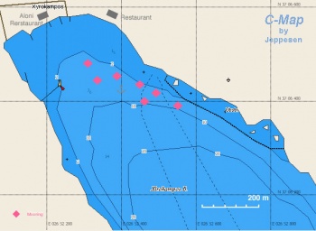
| + | | colspan="2" style="text-align:center; font-size: smaller;" | [[Image:Greece_Leros_Xerocambos_m.jpg|350px]]Chart of Xerocambos - ''Click for larger view'' | ||
|} | |} | ||
| - | + | ||
Xerocambos (Ξηρόκαμπος) or Xirocambos is a very attractive and large anchorage on the S side of the island. It affords very good protection from the ''meltemi'' (although gusts enter the bay) but it is exposed to the S. Around fourteen moorings have been laid in the bay by the tavernas ashore and, if you use one, you will be expected to dine at the taverna concerned. The yellow ones belong to the Aloni Taverna towards the left of the beach (run by Lefteris and Evelyn), which is particularly friendly to yachtsmen. The orange ones belong to the Mama Vita taverna in the centre of the beach. If anchoring, look for a spot of sand and anchor in 5-6 metres (the bottom is mostly weed and holding is not always very good). Once the anchor holds, however, the cove is very secure. It is about one hour walk to Lakki which is also served by bus. | Xerocambos (Ξηρόκαμπος) or Xirocambos is a very attractive and large anchorage on the S side of the island. It affords very good protection from the ''meltemi'' (although gusts enter the bay) but it is exposed to the S. Around fourteen moorings have been laid in the bay by the tavernas ashore and, if you use one, you will be expected to dine at the taverna concerned. The yellow ones belong to the Aloni Taverna towards the left of the beach (run by Lefteris and Evelyn), which is particularly friendly to yachtsmen. The orange ones belong to the Mama Vita taverna in the centre of the beach. If anchoring, look for a spot of sand and anchor in 5-6 metres (the bottom is mostly weed and holding is not always very good). Once the anchor holds, however, the cove is very secure. It is about one hour walk to Lakki which is also served by bus. | ||
| Line 45: | Line 47: | ||
! <center>[[image:Chart_icon.png]]</center> | ! <center>[[image:Chart_icon.png]]</center> | ||
| [http://mapserver.mytopo.com/homepage/index.cfm?lat=37.146667&lon=26.861667&scale=150000&zoom=100&type=0&icon=0&searchscope=dom&CFID=17583484&CFTOKEN=79232580&scriptfile=http://mapserver.mytopo.com/homepage/index.cfm&latlontype=DMS Local chartlet] | | [http://mapserver.mytopo.com/homepage/index.cfm?lat=37.146667&lon=26.861667&scale=150000&zoom=100&type=0&icon=0&searchscope=dom&CFID=17583484&CFTOKEN=79232580&scriptfile=http://mapserver.mytopo.com/homepage/index.cfm&latlontype=DMS Local chartlet] | ||
| + | |- | ||
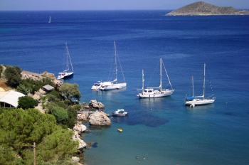
| + | | colspan="2" style="text-align:center; font-size: smaller;" | [[Image:VromolithosAnchorage.jpg|350px]]Yachts anchored at Vromolithos - ''Click for larger view'' | ||
|} | |} | ||
| - | + | ||
Vromolithos (Βρωμόλιθος) is a small anchorage on the SE side of the island, just west of Pandeli, with room for several yachts to anchor in the lee of the headland. Either anchor in 8-12 metres just off the headland and take a long line back to the rocks (this position offers the best protection from the ''meltemi'') or anchor in 6-7 metres outside the buoyed swimming area off the beach. The holding here is good in sand and weed and the shelter also good (although gusts will be experienced with strong N/NW winds). The Paradiso Taverna above the beach does a boiled octopus to die for and Dimitris O Karaflas taverna on top of the headland offers excellent food at sensible prices and is invariably packed with locals. | Vromolithos (Βρωμόλιθος) is a small anchorage on the SE side of the island, just west of Pandeli, with room for several yachts to anchor in the lee of the headland. Either anchor in 8-12 metres just off the headland and take a long line back to the rocks (this position offers the best protection from the ''meltemi'') or anchor in 6-7 metres outside the buoyed swimming area off the beach. The holding here is good in sand and weed and the shelter also good (although gusts will be experienced with strong N/NW winds). The Paradiso Taverna above the beach does a boiled octopus to die for and Dimitris O Karaflas taverna on top of the headland offers excellent food at sensible prices and is invariably packed with locals. | ||
| Line 53: | Line 57: | ||
* August 2010 --[[User:Atheneoflymington|Athene of Lymington]] 16:13, 7 September 2010 (UTC) | * August 2010 --[[User:Atheneoflymington|Athene of Lymington]] 16:13, 7 September 2010 (UTC) | ||
* June 2011 --[[User:Istioploos|Istioploos]] [[Image:Greece_Icon.png]] | * June 2011 --[[User:Istioploos|Istioploos]] [[Image:Greece_Icon.png]] | ||
| - | <div style="clear: | + | <div style="clear: right;"></div> |
===Alindas=== | ===Alindas=== | ||
| Line 68: | Line 72: | ||
! <center>[[image:Chart_icon.png]]</center> | ! <center>[[image:Chart_icon.png]]</center> | ||
| [http://mapserver.maptech.com/homepage/index.cfm?lat=37.16451238590425&lon=26.840901440691162&scale=10000&zoom=50&type=0&icon=0&width=498&height=498&searchscope=dom&CFID=1509264&CFTOKEN=22608242&scriptfile=http://mapserver.maptech.com/homepage/index.cfm&latlontype=DMS Local chartlet] | | [http://mapserver.maptech.com/homepage/index.cfm?lat=37.16451238590425&lon=26.840901440691162&scale=10000&zoom=50&type=0&icon=0&width=498&height=498&searchscope=dom&CFID=1509264&CFTOKEN=22608242&scriptfile=http://mapserver.maptech.com/homepage/index.cfm&latlontype=DMS Local chartlet] | ||
| + | |- | ||
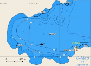
| + | | colspan="2" style="text-align:center; font-size: smaller;" | [[Image:Greece_Leros_Alindas_m.jpg|350px]]Chart of Alindas Bay - ''Click for larger view'']] | ||
|} | |} | ||
| - | + | ||
| - | ´Alindas (Άλινδας) or Alinda is a large bay on the east coast of Leros which offers better protection than would at first appear from the ''meltemi''. Anchor off the beach at the NW end of the bay in 4-5 metres, clear of the numerous small craft moorings, where there is little swell and only moderate gusts in winds up to 6/7 Beaufort. If the gusts get too much, Vromolithos to the south usually offers slightly better shelter. The bottom at Alindas is sand and rock and you may need more than one attempt to get your anchor to hold. Nevertheless, it is an attractive spot with some good tavernas ashore | + | ´Alindas (Άλινδας) or Alinda is a large bay on the east coast of Leros which offers better protection than would at first appear from the ''meltemi''. Anchor off the beach at the NW end of the bay in 4-5 metres, clear of the numerous small craft moorings, where there is little swell and only moderate gusts in winds up to 6/7 Beaufort. If the gusts get too much, Vromolithos to the south usually offers slightly better shelter. The bottom at Alindas is sand and rock and you may need more than one attempt to get your anchor to hold. Nevertheless, it is an attractive spot with some good tavernas ashore. There is also an interesting folklore/WW II museum in a nicely maintained private mansion, the ''Bellinis Tower''. |
====Last Visited & Details Checked (and updated here)==== | ====Last Visited & Details Checked (and updated here)==== | ||
| Line 77: | Line 83: | ||
* June 2012 --[[User:Istioploos|Istioploos]] [[Image:Greece_Icon.png]] | * June 2012 --[[User:Istioploos|Istioploos]] [[Image:Greece_Icon.png]] | ||
| - | <div style="clear: both;">[[Image:AlindasAnchorage.jpg|thumb| | + | <div style="clear: both;">[[Image:AlindasAnchorage.jpg|thumb|345px|center| The anchorage at Alindas<br />''Click for larger view'']]</div> |
===Blefouti=== | ===Blefouti=== | ||
| Line 115: | Line 121: | ||
! <center>[[image:Chart_icon.png]]</center> | ! <center>[[image:Chart_icon.png]]</center> | ||
| [http://mapserver.maptech.com/homepage/index.cfm?lat=37.191667&lon=26.805&scale=20000&zoom=100&type=0&icon=0&searchscope=dom&CFID=1509264&CFTOKEN=22608242&scriptfile=http://mapserver.maptech.com/homepage/index.cfm&latlontype=DMS Local chartlet] | | [http://mapserver.maptech.com/homepage/index.cfm?lat=37.191667&lon=26.805&scale=20000&zoom=100&type=0&icon=0&searchscope=dom&CFID=1509264&CFTOKEN=22608242&scriptfile=http://mapserver.maptech.com/homepage/index.cfm&latlontype=DMS Local chartlet] | ||
| + | |- | ||
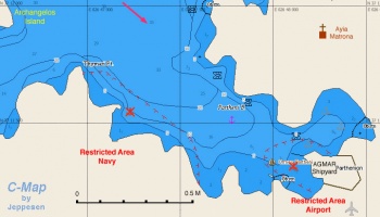
| + | | colspan="2" style="text-align:center; font-size: smaller;" | [[Image:Greece_Leros_Partheni_m.jpg|350px]]Chart of Partheni - ''Click for larger view'' | ||
|} | |} | ||
| - | + | ||
| - | + | Partheni (Παρθένι) is a large landlocked bay on the N side of the island. There is a naval installation on the W side of the bay and a military camp to the SE. [http://www.lakki-marina.gr/ Agmar] ([[image:World_icon.png]] {{Coord|37|11.31|N|26|48.02|E|}}) operates a [[Leros#Agmar_Shipyard|shipyard]] with a 70 ton travel lift; for details see below. Agmar maintains four mooring buoys in front of its facilities, which clients can use temporarily. The airport is only 100 metres away. | |
| - | Partheni (Παρθένι) is a large landlocked bay on the N side of the island. There is a naval installation on the W side of the bay and a military camp to the SE. [http://www.lakki-marina.gr/ Agmar] ([[image:World_icon.png]] {{Coord|37|11.31|N|26|48.02|E|}}) operates a [[#Agmar_Shipyard|shipyard]] with a 70 ton travel lift; for details see below. Agmar maintains four mooring buoys in front of its facilities, which clients can use temporarily. The airport is only 100 metres away. | + | |
There is excellent protection on the north side of the inner cove at the eastern end of the bay. Anchor clear of the numerous moorings on the south side of the cove and the small fish farm to the northwest. Even in a strong ''meltemi'' your boat is safe here. However, the setting is not very attractive and there is nothing in the way of facilities. The nearest taverna is opposite the airport some two kilometres away. Added to this is the presence of the military camp, the site of the notorious Partheni prison where many political prisoners were tortured during the days of the [http://en.wikipedia.org/wiki/Greek_junta junta]. | There is excellent protection on the north side of the inner cove at the eastern end of the bay. Anchor clear of the numerous moorings on the south side of the cove and the small fish farm to the northwest. Even in a strong ''meltemi'' your boat is safe here. However, the setting is not very attractive and there is nothing in the way of facilities. The nearest taverna is opposite the airport some two kilometres away. Added to this is the presence of the military camp, the site of the notorious Partheni prison where many political prisoners were tortured during the days of the [http://en.wikipedia.org/wiki/Greek_junta junta]. | ||
| Line 128: | Line 135: | ||
<div style="clear: both;"> | <div style="clear: both;"> | ||
| - | [[Image:PartheniAnchorage.jpg|thumb| | + | [[Image:PartheniAnchorage.jpg|thumb|345px|center|The inner anchorage at Partheni<br />''Click for larger view'']] |
</div> | </div> | ||
| Line 149: | Line 156: | ||
* | * | ||
| - | == | + | ==Berthing Options== |
''See [[#Marinas & Yacht Clubs|Marinas & Yacht Clubs]] below''. | ''See [[#Marinas & Yacht Clubs|Marinas & Yacht Clubs]] below''. | ||
| - | |||
| - | ==Marinas & Yacht Clubs== | + | ===Marinas & Yacht Clubs=== |
* [[Agmar Lakki Marina]] | * [[Agmar Lakki Marina]] | ||
* [[Evros Leros Marina]] | * [[Evros Leros Marina]] | ||
| + | ==Offshore Islands== | ||
| + | ''See [[Leros#Offshore Islands|Leros]]''. | ||
==Yacht Services and Repairs== | ==Yacht Services and Repairs== | ||
''See [[Leros#Yacht Services and Repairs|Leros]]''. | ''See [[Leros#Yacht Services and Repairs|Leros]]''. | ||
| - | |||
| - | |||
| - | |||
==Things to do Ashore== | ==Things to do Ashore== | ||
| - | ''Please see | + | ''Please see [[Leros#Tourism_and_Things_to_do_Ashore|Leros]]''. |
==Routes/Passages To/From== | ==Routes/Passages To/From== | ||
| - | ''See | + | ''See [[Leros#Routes.2FPassages_To.2FFrom|Leros]]''. |
==Cruiser's Friends== | ==Cruiser's Friends== | ||
| Line 175: | Line 180: | ||
==Forum Discussions== | ==Forum Discussions== | ||
| - | List links to discussion threads on [[Cruising Forums|partnering forums]]. (see link for requirements) | + | List links to discussion threads on [[Cruising Forums|partnering forums]]. (''see link for requirements'') |
* | * | ||
* | * | ||
| Line 184: | Line 189: | ||
==References & Publications== | ==References & Publications== | ||
| - | See [[Greece#References_&_Publications|Greece]]. | + | ''See [[Greece#References_&_Publications|Greece]]''. |
| - | |||
| - | |||
==Personal Notes== | ==Personal Notes== | ||
Personal experiences? | Personal experiences? | ||
* | * | ||
| + | |||
| + | |||
| + | ====Last Visited & Details Checked (and updated here)==== | ||
| + | ''See individual anchorages in this page''. | ||
{{Guide2}} | {{Guide2}} | ||
| + | |||
<br /> | <br /> | ||
Revision as of 16:34, 9 February 2013
Anchorages of Leros Island, Greece
Leros.Xerocambos
| | |
| | 37°06.45′N, 26°52.3′E |
|---|---|
| | Photo gallery |
| | Local chartlet |
 Chart of Xerocambos - Click for larger view Chart of Xerocambos - Click for larger view
| |
Xerocambos (Ξηρόκαμπος) or Xirocambos is a very attractive and large anchorage on the S side of the island. It affords very good protection from the meltemi (although gusts enter the bay) but it is exposed to the S. Around fourteen moorings have been laid in the bay by the tavernas ashore and, if you use one, you will be expected to dine at the taverna concerned. The yellow ones belong to the Aloni Taverna towards the left of the beach (run by Lefteris and Evelyn), which is particularly friendly to yachtsmen. The orange ones belong to the Mama Vita taverna in the centre of the beach. If anchoring, look for a spot of sand and anchor in 5-6 metres (the bottom is mostly weed and holding is not always very good). Once the anchor holds, however, the cove is very secure. It is about one hour walk to Lakki which is also served by bus.
About an hour walk up the ridge on the E side of Xerocambos there is an abandoned WW II Italian house with wall frescoes painted by the Italian soldiers garrisoned there.
Last Visited & Details Checked (and updated here)
Date of member's visit to this Port/Stop & this page's details validated:
- July 2010 --Athene of Lymington 13:38, 10 July 2010 (UTC)
- August 2012 --Istioploos

Vromolithos
| | |
| | 37°08.8′N, 26°51.7′E |
|---|---|
| | Photo gallery |
| | Local chartlet |
 Yachts anchored at Vromolithos - Click for larger view Yachts anchored at Vromolithos - Click for larger view
| |
Vromolithos (Βρωμόλιθος) is a small anchorage on the SE side of the island, just west of Pandeli, with room for several yachts to anchor in the lee of the headland. Either anchor in 8-12 metres just off the headland and take a long line back to the rocks (this position offers the best protection from the meltemi) or anchor in 6-7 metres outside the buoyed swimming area off the beach. The holding here is good in sand and weed and the shelter also good (although gusts will be experienced with strong N/NW winds). The Paradiso Taverna above the beach does a boiled octopus to die for and Dimitris O Karaflas taverna on top of the headland offers excellent food at sensible prices and is invariably packed with locals.
Last Visited & Details Checked (and updated here)
Date of member's visit to this Port/Stop & this page's details validated:
- August 2010 --Athene of Lymington 16:13, 7 September 2010 (UTC)
- June 2011 --Istioploos

Alindas
| | |
| | 37°10′N, 26°50.4′E |
|---|---|
| | Photo gallery |
| | Local chartlet |
 Chart of Alindas Bay - Click for larger view]] Chart of Alindas Bay - Click for larger view]]
| |
´Alindas (Άλινδας) or Alinda is a large bay on the east coast of Leros which offers better protection than would at first appear from the meltemi. Anchor off the beach at the NW end of the bay in 4-5 metres, clear of the numerous small craft moorings, where there is little swell and only moderate gusts in winds up to 6/7 Beaufort. If the gusts get too much, Vromolithos to the south usually offers slightly better shelter. The bottom at Alindas is sand and rock and you may need more than one attempt to get your anchor to hold. Nevertheless, it is an attractive spot with some good tavernas ashore. There is also an interesting folklore/WW II museum in a nicely maintained private mansion, the Bellinis Tower.
Last Visited & Details Checked (and updated here)
Date of member's visit to this Port/Stop & this page's details validated:
- July 2010 --Athene of Lymington 14:12, 9 July 2010 (UTC)
- June 2012 --Istioploos

Blefouti
| | |
| | 37°11.6′N, 26°49.2′E |
|---|---|
| | Photo gallery |
| | Local chartlet |
Blefouti (Μπλεφούτι) or Blefoutis or Plakouti is an attractive cove on the NE side of the island. It is reasonably well protected from the meltemi (though shelter is not as good as at Partheni) and in winds from W through to SE. The most sheltered, westerly, side of the anchorage is mostly taken up with small boat moorings and yachts therefore need to anchor closer to the middle of the cove. The bottom is sand and weed, not always good holding. There is a small taverna ashore, I Thea Artemis, which serves good fish.
Danger: There are several reefs at the entrance to the cove. Enter from the E of the reef.
Last Visited & Details Checked (and updated here)
Date of member's visit to this Port/Stop & this page's details validated:
- July 2009 --Atheneoflymington 14:11, 16 July 2009 (UTC)
- April 2012 --Istioploos

Partheni
| | |
| | 37°11.5′N, 26°48.3′E |
|---|---|
| | Photo gallery |
| | Local chartlet |
 Chart of Partheni - Click for larger view Chart of Partheni - Click for larger view
| |
Partheni (Παρθένι) is a large landlocked bay on the N side of the island. There is a naval installation on the W side of the bay and a military camp to the SE. Agmar (![]() 37°11.31′N, 26°48.02′E) operates a shipyard with a 70 ton travel lift; for details see below. Agmar maintains four mooring buoys in front of its facilities, which clients can use temporarily. The airport is only 100 metres away.
37°11.31′N, 26°48.02′E) operates a shipyard with a 70 ton travel lift; for details see below. Agmar maintains four mooring buoys in front of its facilities, which clients can use temporarily. The airport is only 100 metres away.
There is excellent protection on the north side of the inner cove at the eastern end of the bay. Anchor clear of the numerous moorings on the south side of the cove and the small fish farm to the northwest. Even in a strong meltemi your boat is safe here. However, the setting is not very attractive and there is nothing in the way of facilities. The nearest taverna is opposite the airport some two kilometres away. Added to this is the presence of the military camp, the site of the notorious Partheni prison where many political prisoners were tortured during the days of the junta.
Last Visited & Details Checked (and updated here)
Date of member's visit to this Port/Stop & this page's details validated:
- July 2010 --Athene of Lymington 14:12, 9 July 2010 (UTC)
- August 2012 --Istioploos

N Cove
![]() 37°12.1′N, 26°47.9′E
37°12.1′N, 26°47.9′E
This is a small pleasant cove just N of Partheni. The cove is somewhat exposed to the meltemi but in settled weather it a good place to stop for a swim. Good holding at 6 m.
Last Visited & Details Checked (and updated here)
Date of member's visit to this Port/Stop & this page's details validated:
- October 2001 --Istioploos

NW Cove
![]() 37°11.5′N, 26°46.6′E
37°11.5′N, 26°46.6′E
While this cove is well protected from the S winds, it is not as good an anchorage as it looks because it is deep and then it gets shallow very quickly and at depths of 3-5 m there is lot of weed with very few patches of sand so the anchor may not hold well here.
Last Visited & Details Checked (and updated here)
Date of member's visit to this Port/Stop & this page's details validated:
- September 2005 --Istioploos

Berthing Options
See Marinas & Yacht Clubs below.
Marinas & Yacht Clubs
Offshore Islands
See Leros.
Yacht Services and Repairs
See Leros.
Things to do Ashore
Please see Leros.
Routes/Passages To/From
See Leros.
Cruiser's Friends
- Travels with S/Y Thetis Vasilis Riginos has been cruising Greek and Turkish waters for over 25 years, as well as having crossed the Atlantic. He winters his boat in Leros. He lives for 6-7 months of the year in Greece and is willing to help any fellow cruisers. Email: vasilis[AT]sy-thetis.org
Forum Discussions
List links to discussion threads on partnering forums. (see link for requirements)
External Links
- Leros (Wikipedia)
References & Publications
See Greece.
Personal Notes
Personal experiences?
Last Visited & Details Checked (and updated here)
See individual anchorages in this page.
|
|---|
|
Names: Istioploos, Lighthouse, Athene of Lymington, Nereus |
| |
|---|
| | HOMEPAGE | Wiki Contents | Mediterranean | Aegean Sea | Greece | Leros | Leros Anchorages | |


