Drače
From CruisersWiki
m |
Istioploos (Talk | contribs) (Template) |
||
| Line 1: | Line 1: | ||
| - | {{IsPartOf|Mediterranean|Adriatic Sea|Croatia|Southern Dalmatia| | + | {{IsPartOf|Mediterranean|Adriatic Sea|Croatia|Southern Dalmatia|Pelješac}} |
{{TOC block}} | {{TOC block}} | ||
| + | |||
{{Infobox | {{Infobox | ||
| lat=42.929468| lon=17.450109 | | lat=42.929468| lon=17.450109 | ||
| + | | name= Drače | ||
| zoom= 15 | | zoom= 15 | ||
| image= DraceAerial.jpg | | image= DraceAerial.jpg | ||
| imagetext= The small harbour of Drace from WSW | | imagetext= The small harbour of Drace from WSW | ||
| chartlet=y | | chartlet=y | ||
| - | | summary= | + | | summary=The small harbour of [[Drače]] lies on the W side of the '''Neretvanski Kanal''', the channel between the mainland and the [[Pelješac|Peljesac Peninsula]] on the Adriatic coast of [[Croatia]], around 14 miles NW of the historic settlement of [[Mali Ston]] at the head of the channel. Drače is a popular holiday spot with a large campsite and the five-mile-long bay in which it sits is dotted with numerous small islets. |
| - | The small harbour of | + | |
| - | While most of the harbour is shallow, a yacht can tie up alongside the outer arm of the breakwater, where there are depths of around 4.0 metres. | + | While most of the harbour is shallow, a yacht can tie up alongside the outer arm of the breakwater, where there are depths of around 4.0 metres. The shelter is good in all conditions except strong SE winds, which send in a significant surge. |
| + | | notes= | ||
| + | | news= | ||
}} | }} | ||
==Charts== | ==Charts== | ||
| - | + | ''See [[Southern Dalmatia#Charts|Southern Dalmatia]]''. | |
| - | | | + | |
| - | + | ||
| - | + | ||
| - | + | ||
==Weather== | ==Weather== | ||
| Line 30: | Line 29: | ||
==Communication== | ==Communication== | ||
| + | {{Green|Add here VHF channel for the coastguard, harbor masters. etc.}} | ||
* | * | ||
| + | * | ||
''Also see [[World MM Nets|World Cruiser's Nets]]''. | ''Also see [[World MM Nets|World Cruiser's Nets]]''. | ||
==Navigation== | ==Navigation== | ||
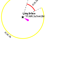
| - | + | [[Drače]] lies at the W end of a large bay which is dotted with numerous islets and rocky shoals, together with several shellfish beds and mussel rafts. Unless you have a large-scale chart, the safest approach is from NNE, giving all the islets a wide berth. The breakwater of [[#Drače harbour|Drače harbour]] and the light structure on the end of it is clearly visible on closer approach. | |
==Berthing== | ==Berthing== | ||
| - | {{ | + | {{poi | lat= 42.9302|lon=17.44981 |
| - | + | | type= harbour | |
| - | Tie up alongside or stern/bows-to the inner side of the northern breakwater (the one with the light on it), where there are depths of around 4.0 metres. | + | | name= Drače harbour |
| + | | altname= | ||
| + | | url = | ||
| + | | zoom= 17 | ||
| + | | portofentry= | ||
| + | | image= DracePier.jpg | ||
| + | | imagetext= The breakwater at Drače from the S | ||
| + | | text= Tie up alongside or stern/bows-to the inner side of the northern breakwater (the one with the light on it), where there are depths of around 4.0 metres. Shelter here is good in winds from most directions, though strong SE winds send in a swell. The holding is good in sand. | ||
| + | }} | ||
| + | |||
| + | {{Image right|DraceWaterfront.jpg|The waterfront of Drače }} | ||
| + | |||
| + | ===Marinas & Yacht Clubs=== | ||
| + | None. | ||
==Anchorages== | ==Anchorages== | ||
| Line 46: | Line 60: | ||
==Amenities== | ==Amenities== | ||
| - | + | None. | |
| - | + | ||
| - | + | ||
| - | + | ||
| - | + | ||
| - | + | ||
| - | + | ||
| - | + | ||
| - | + | ||
| - | + | ||
| - | + | ||
| - | + | ||
| - | + | ||
| - | + | ||
| - | + | ||
| - | + | ||
| - | + | ||
| - | + | ||
| - | + | ||
| - | + | ||
| - | + | ||
| - | + | ||
| - | + | ||
| - | + | ||
| - | + | ||
| - | + | ||
==Provisioning== | ==Provisioning== | ||
| - | A small provisions shop | + | {{mark | type= provisions |name= In the campsite |text= A small provisions shop.}} |
==Eating out== | ==Eating out== | ||
| - | Café/bar and a small restaurant. | + | * In the Town |
| + | : {{mark |name= | type= eatingout | text=Café/bar and a small restaurant.}} | ||
==Transportation== | ==Transportation== | ||
| Line 83: | Line 73: | ||
==Tourism== | ==Tourism== | ||
| - | There is little ashore in | + | There is little ashore in Drače but the surroundings are attractive. |
==Links== | ==Links== | ||
| - | + | * {{Wikipedia}} | |
* | * | ||
| Line 94: | Line 84: | ||
''See [[Croatia#References|Croatia]]''. | ''See [[Croatia#References|Croatia]]''. | ||
| - | {{Comments | + | {{Comments}} |
| + | * | ||
| + | * | ||
{{Verified by}} | {{Verified by}} | ||
| - | |||
* Data compiled from web research (please update if possible) --[[User:Atheneoflymington|Athene of Lymington]] | * Data compiled from web research (please update if possible) --[[User:Atheneoflymington|Athene of Lymington]] | ||
* | * | ||
Revision as of 21:20, 2 May 2019
| Drače
| |
| |
 The small harbour of Drace from WSW |
The small harbour of Drače lies on the W side of the Neretvanski Kanal, the channel between the mainland and the Peljesac Peninsula on the Adriatic coast of Croatia, around 14 miles NW of the historic settlement of Mali Ston at the head of the channel. Drače is a popular holiday spot with a large campsite and the five-mile-long bay in which it sits is dotted with numerous small islets.
While most of the harbour is shallow, a yacht can tie up alongside the outer arm of the breakwater, where there are depths of around 4.0 metres. The shelter is good in all conditions except strong SE winds, which send in a significant surge.
Charts
See Southern Dalmatia.
Weather
See Croatia.
Passages
See Croatia.
Islands
Several small islets in the bay.
Communication
Add here VHF channel for the coastguard, harbor masters. etc.
Also see World Cruiser's Nets.
Drače lies at the W end of a large bay which is dotted with numerous islets and rocky shoals, together with several shellfish beds and mussel rafts. Unless you have a large-scale chart, the safest approach is from NNE, giving all the islets a wide berth. The breakwater of Drače harbour and the light structure on the end of it is clearly visible on closer approach.
Berthing

Drače harbour

Marinas & Yacht Clubs
None.
Anchorages
None.
Amenities
None.
Provisioning
![]() In the campsite [[Drače#In the campsite|In the campsite]] A small provisions shop.
In the campsite [[Drače#In the campsite|In the campsite]] A small provisions shop.
Eating out
- In the Town
-
 [[Drače# | ]] Café/bar and a small restaurant.
Transportation
Buses to local destinations.
Tourism
There is little ashore in Drače but the surroundings are attractive.
Links
- Drače at the Wikipedia
For other useful websites, see Croatia.
References
See Croatia.
Comments
We welcome users' contributions to the Wiki. Please click on Comments to view other users' comments, add your own personal experiences or recommend any changes to this page following your visit.
Verified by
Date of member's last visit to Drače and this page's details validated:
- Data compiled from web research (please update if possible) --Athene of Lymington
| This page has an outline in place but needs completing. Please contribute if you can to help it grow further. Click on Comments to suggest further content or alternatively, if you feel confident to edit this page, click on the edit tab at the top and enter your changes directly. |
| |
|---|
|
Names: Haiqu, Athene of Lymington |